Wamboin geodata
Wamboin (New South Wales) is a section of populated place; located in Australia in Australia/Sydney (GMT+11) time zone. With population of 1,677 people, there are 3118 cities with bigger population in this country. Compared to other cities in Australia, 74.9% of cities are located further ↑North; 56% of cities are located further ←West and 99% of cities have lower elevation than Wamboin. Note1


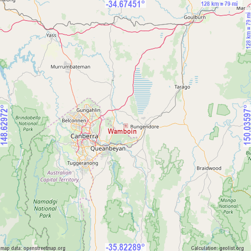
Wamboin GPS coordinates[2]
35° 15' 2.628" South, 149° 19' 58.224" East
| Map corner | latitude | longitude |
|---|---|---|
| Upper-left | -34.67451°, | 148.62972° |
| Center: | -35.25073°, | 149.33284° |
| Lower-right: | -35.82289°, | 150.03597° |
| Map W x H: | 127.7×127.7 km | = 79.3×79.3mi |
| max Lat: | -10.58257° ⇑74.9% North |
| Wamboin: | -35.25073° |
| min Lat: | ⇓25.1% South -43.31423° |
| min Long | Wamboin | max Long |
| 113.53327° | 149.33284° | 153.61246° |
| W 56%⇐ | ⇒44% E |
Elevation
Elevation of Wamboin is 796 m = 2612 ft, and this is 674 m = 2211 ft above average elevation for this country.
| Max E: |
1715 m = 5627 ft | 1% |
| Wamboin | 796 m 2612 ft | |
| Avg. | 122 m = 400 ft | |
Min E: |
-2 m = -7 ft | 99% |
See also: Australia elevation on elevation.city.
Geographical zone
Wamboin is located in South temperate zone (between Tropic of Capricorn and the Antarctic Circle). Distance of this Southern Tropic circle is 1313.6 km =816.2 mi to North.| Distance of | km | miles | from Wamboin |
|---|---|---|---|
| Equator | 3919.5 | 2435.5 | to North |
| Tropic Capricorn | 1313.6 | 816.2 | to North |
| Antarctic Circle | 3481.7 | 2163.4 | to South |
| South Pole | 6087.5 | 3782.6 | to South |


Nearby cities:
15 places around Wamboin: (largest is in red/bold)
• Bungendore
9.7 km =6 mi,  92°
92°
• Bywong
9.6 km =6 mi,  357°
357°
• Campbell
16.8 km =10.4 mi,  255°
255°
• Carwoola
14.2 km =8.8 mi,  184°
184°
• Crestwood
15.1 km =9.4 mi,  223°
223°
• Downer
17.1 km =10.6 mi,  272°
272°
• Greenleigh
14.8 km =9.2 mi,  209°
209°
• Hackett
15.4 km =9.6 mi, 270°
• Harrison
17 km =10.6 mi,  289°
289°
• Karabar
16.6 km =10.3 mi, 213°
• Queanbeyan
14.8 km =9.2 mi, 218°
• Queanbeyan East
13.2 km =8.2 mi, 216°
• Queanbeyan West
16.5 km =10.3 mi,  225°
225°
• Sutton
12 km =7.5 mi,  321°
321°
• Watson
16.4 km =10.2 mi, 274°
Sources, notices
• [Note1] Compared only with cities in Australia existing in our database
• [Src1] Map data: © OpenStreetMap contributors (CC-BY-SA)
• [Src2] Other city data from geonames.org with taken over terms of usage.
• [Src3] Geographical zone / Annual Mean Temperature by Robert A. Rohde @ Wikipedia
