Bulla geodata
Bulla (Victoria) is a section of populated place; located in Australia in Australia/Melbourne (GMT+11) time zone. With population of 667 people, there are 4388 cities with bigger population in this country. Compared to other cities in Australia, 83.8% of cities are located further ↑North; 68.8% of cities are located further →East and 77.8% of cities have lower elevation than Bulla. Note1


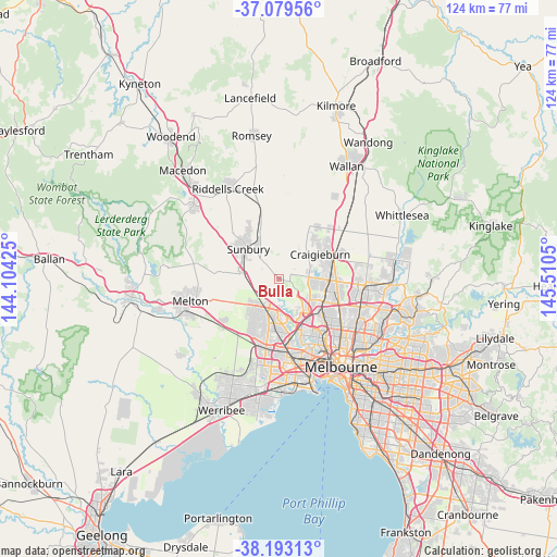
Bulla GPS coordinates[2]
37° 38' 18.348" South, 144° 48' 26.532" East
| Map corner | latitude | longitude |
|---|---|---|
| Upper-left | -37.07956°, | 144.10425° |
| Center: | -37.63843°, | 144.80737° |
| Lower-right: | -38.19313°, | 145.5105° |
| Map W x H: | 123.8×123.8 km | = 76.9×76.9mi |
| max Lat: | -10.58257° ⇑83.8% North |
| Bulla: | -37.63843° |
| min Lat: | ⇓16.2% South -43.31423° |
| min Long | Bulla | max Long |
| 113.53327° | 144.80737° | 153.61246° |
| W 31.2%⇐ | ⇒68.8% E |
Elevation
Elevation of Bulla is 154 m = 505 ft, and this is 32 m = 105 ft above average elevation for this country.
| Max E: |
1715 m = 5627 ft | 22.2% |
| Bulla | 154 m 505 ft | |
| Avg. | 122 m = 400 ft | |
Min E: |
-2 m = -7 ft | 77.8% |
See also: Australia elevation on elevation.city.
Geographical zone
Bulla is located in South temperate zone (between Tropic of Capricorn and the Antarctic Circle). Distance of this Southern Tropic circle is 1579.1 km =981.2 mi to North.| Distance of | km | miles | from Bulla |
|---|---|---|---|
| Equator | 4185 | 2600.4 | to North |
| Tropic Capricorn | 1579.1 | 981.2 | to North |
| Antarctic Circle | 3216.2 | 1998.5 | to South |
| South Pole | 5822.1 | 3617.7 | to South |


Nearby cities:
15 places around Bulla: (largest is in red/bold)
• Attwood
7.8 km =4.8 mi,  116°
116°
• Delahey
9.4 km =5.8 mi,  196°
196°
• Diggers Rest
7.9 km =4.9 mi,  280°
280°
• Gladstone Park
8.9 km =5.5 mi,  127°
127°
• Greenvale
5.3 km =3.3 mi,  83°
83°
• Hillside
8.2 km =5.1 mi,  224°
224°
• Keilor
9 km =5.6 mi,  165°
165°
• Keilor Downs
9.4 km =5.8 mi,  179°
179°
• Keilor Lodge
6.9 km =4.3 mi, 182°
• Melbourne Airport
5.6 km =3.5 mi,  135°
135°
• Sydenham
7.7 km =4.8 mi,  207°
207°
• Taylors Hill
9.2 km =5.7 mi, 210°
• Taylors Lakes
6.9 km =4.3 mi, 195°
• Tullamarine
9.5 km =5.9 mi, 137°
• Westmeadows
8.2 km =5.1 mi, 120°
Sources, notices
• [Note1] Compared only with cities in Australia existing in our database
• [Src1] Map data: © OpenStreetMap contributors (CC-BY-SA)
• [Src2] Other city data from geonames.org with taken over terms of usage.
• [Src3] Geographical zone / Annual Mean Temperature by Robert A. Rohde @ Wikipedia
