Biboohra geodata
Biboohra (Queensland) is a populated place; located in Australia in Australia/Brisbane (GMT+10) time zone. With population of 587 people, there are 4607 cities with bigger population in this country. Compared to other cities in Australia, 97.5% of cities are located further ↓South; 60.1% of cities are located further →East and 91.3% of cities have lower elevation than Biboohra. Note1


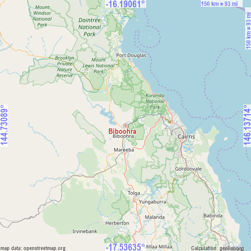
Biboohra GPS coordinates[2]
16° 51' 52.848" South, 145° 26' 2.436" East
| Map corner | latitude | longitude |
|---|---|---|
| Upper-left | -16.19061°, | 144.73089° |
| Center: | -16.86468°, | 145.43401° |
| Lower-right: | -17.53635°, | 146.13714° |
| Map W x H: | 149.6×149.6 km | = 93×93mi |
| max Lat: | -10.58257° ⇑2.5% North |
| Biboohra: | -16.86468° |
| min Lat: | ⇓97.5% South -43.31423° |
| min Long | Biboohra | max Long |
| 113.53327° | 145.43401° | 153.61246° |
| W 39.9%⇐ | ⇒60.1% E |
Elevation
Elevation of Biboohra is 422 m = 1385 ft, and this is 300 m = 984 ft above average elevation for this country.
| Max E: |
1715 m = 5627 ft | 8.7% |
| Biboohra | 422 m 1385 ft | |
| Avg. | 122 m = 400 ft | |
Min E: |
-2 m = -7 ft | 91.3% |
See also: Australia elevation on elevation.city.
Geographical zone
Biboohra is located in South Torrid zone (between Equator and Tropic of Capricorn). Distance of this Southern Tropic circle is 730.7 km =454 mi to South.| Distance of | km | miles | from Biboohra |
|---|---|---|---|
| Equator | 1875.2 | 1165.2 | to North |
| Tropic Capricorn | 730.7 | 454 | to South |
| Antarctic Circle | 5526 | 3433.7 | to South |
| South Pole | 8131.9 | 5052.9 | to South |


Nearby cities:
15 places around Biboohra: (largest is in red/bold)
• Brinsmead
30.2 km =18.8 mi,  97°
97°
• Caravonica
26.3 km =16.3 mi,  91°
91°
• Clifton Beach
27.7 km =17.2 mi,  65°
65°
• Freshwater
30.1 km =18.7 mi, 93°
• Kamerunga
28.5 km =17.7 mi, 91°
• Kewarra Beach
28.2 km =17.5 mi, 71°
• Koah
12.7 km =7.9 mi, 100°
• Kuranda
22.3 km =13.9 mi,  77°
77°
• Mareeba
14.1 km =8.8 mi,  184°
184°
• Palm Cove
27.9 km =17.3 mi,  62°
62°
• Redlynch
28.6 km =17.8 mi, 103°
• Speewah
19.3 km =12 mi, 98°
• Trinity Beach
29.2 km =18.1 mi, 73°
• Trinity Park
29.6 km =18.4 mi, 77°
• Walkamin
30.3 km =18.8 mi, 183°
Sources, notices
• [Note1] Compared only with cities in Australia existing in our database
• [Src1] Map data: © OpenStreetMap contributors (CC-BY-SA)
• [Src2] Other city data from geonames.org with taken over terms of usage.
• [Src3] Geographical zone / Annual Mean Temperature by Robert A. Rohde @ Wikipedia
