Koah geodata
Koah (Queensland) is a populated place; located in Australia in Australia/Brisbane (GMT+10) time zone. With population of 610 people, there are 4543 cities with bigger population in this country. Compared to other cities in Australia, 97.4% of cities are located further ↓South; 59.4% of cities are located further →East and 90.6% of cities have lower elevation than Koah. Note1


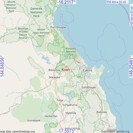
Koah GPS coordinates[2]
16° 53' 8.52" South, 145° 33' 6.048" East
| Map corner | latitude | longitude |
|---|---|---|
| Upper-left | -16.2117°, | 144.84856° |
| Center: | -16.8857°, | 145.55168° |
| Lower-right: | -17.5573°, | 146.25481° |
| Map W x H: | 149.6×149.6 km | = 93×93mi |
| max Lat: | -10.58257° ⇑2.6% North |
| Koah: | -16.8857° |
| min Lat: | ⇓97.4% South -43.31423° |
| min Long | Koah | max Long |
| 113.53327° | 145.55168° | 153.61246° |
| W 40.6%⇐ | ⇒59.4% E |
Elevation
Elevation of Koah is 396 m = 1299 ft, and this is 274 m = 899 ft above average elevation for this country.
| Max E: |
1715 m = 5627 ft | 9.4% |
| Koah | 396 m 1299 ft | |
| Avg. | 122 m = 400 ft | |
Min E: |
-2 m = -7 ft | 90.6% |
See also: Australia elevation on elevation.city.
Geographical zone
Koah is located in South Torrid zone (between Equator and Tropic of Capricorn). Distance of this Southern Tropic circle is 728.4 km =452.6 mi to South.| Distance of | km | miles | from Koah |
|---|---|---|---|
| Equator | 1877.5 | 1166.6 | to North |
| Tropic Capricorn | 728.4 | 452.6 | to South |
| Antarctic Circle | 5523.7 | 3432.3 | to South |
| South Pole | 8129.5 | 5051.4 | to South |


Nearby cities:
15 places around Koah: (largest is in red/bold)
• Biboohra
12.7 km =7.9 mi,  280°
280°
• Brinsmead
17.5 km =10.9 mi,  94°
94°
• Caravonica
13.9 km =8.6 mi,  83°
83°
• Clifton Beach
18.7 km =11.6 mi,  43°
43°
• Freshwater
17.6 km =10.9 mi, 89°
• Kamerunga
16 km =9.9 mi, 85°
• Kanimbla
18.5 km =11.5 mi,  102°
102°
• Kewarra Beach
18.2 km =11.3 mi,  50°
50°
• Kuranda
11.8 km =7.3 mi, 51°
• Mareeba
18 km =11.2 mi,  229°
229°
• Palm Cove
19.4 km =12.1 mi, 39°
• Redlynch
15.9 km =9.9 mi,  106°
106°
• Speewah
6.6 km =4.1 mi, 93°
• Trinity Beach
18.8 km =11.7 mi,  55°
55°
• Trinity Park
18.6 km =11.6 mi, 61°
Sources, notices
• [Note1] Compared only with cities in Australia existing in our database
• [Src1] Map data: © OpenStreetMap contributors (CC-BY-SA)
• [Src2] Other city data from geonames.org with taken over terms of usage.
• [Src3] Geographical zone / Annual Mean Temperature by Robert A. Rohde @ Wikipedia
