Berowra geodata
Berowra (New South Wales) is a section of populated place; located in Australia in Australia/Sydney (GMT+11) time zone. With population of 4,586 people, there are 1602 cities with bigger population in this country. Compared to other cities in Australia, 52.4% of cities are located further ↓South; 71.8% of cities are located further ←West and 82.5% of cities have lower elevation than Berowra. Note1


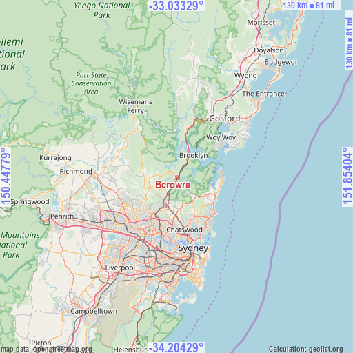
Berowra GPS coordinates[2]
33° 37' 14.808" South, 151° 9' 3.276" East
| Map corner | latitude | longitude |
|---|---|---|
| Upper-left | -33.03329°, | 150.44779° |
| Center: | -33.62078°, | 151.15091° |
| Lower-right: | -34.20429°, | 151.85404° |
| Map W x H: | 130.2×130.2 km | = 80.9×80.9mi |
| max Lat: | -10.58257° ⇑47.6% North |
| Berowra: | -33.62078° |
| min Lat: | ⇓52.4% South -43.31423° |
| min Long | Berowra | max Long |
| 113.53327° | 151.15091° | 153.61246° |
| W 71.8%⇐ | ⇒28.2% E |
Elevation
Elevation of Berowra is 212 m = 696 ft, and this is 90 m = 295 ft above average elevation for this country.
| Max E: |
1715 m = 5627 ft | 17.5% |
| Berowra | 212 m 696 ft | |
| Avg. | 122 m = 400 ft | |
Min E: |
-2 m = -7 ft | 82.5% |
See also: Australia elevation on elevation.city.
Geographical zone
Berowra is located in South temperate zone (between Tropic of Capricorn and the Antarctic Circle). Distance of this Southern Tropic circle is 1132.4 km =703.6 mi to North.| Distance of | km | miles | from Berowra |
|---|---|---|---|
| Equator | 3738.3 | 2322.9 | to North |
| Tropic Capricorn | 1132.4 | 703.6 | to North |
| Antarctic Circle | 3662.9 | 2276 | to South |
| South Pole | 6268.8 | 3895.3 | to South |


Nearby cities:
15 places around Berowra: (largest is in red/bold)
• Arcadia
10.9 km =6.8 mi,  272°
272°
• Asquith
8 km =5 mi,  203°
203°
• Berowra Heights
1.6 km =1 mi,  307°
307°
• Brooklyn
10.5 km =6.5 mi,  40°
40°
• Cowan
3.2 km =2 mi,  30°
30°
• Galston
10.3 km =6.4 mi,  249°
249°
• Hornsby
10.3 km =6.4 mi,  207°
207°
• Hornsby Heights
7.7 km =4.8 mi,  223°
223°
• Mount Colah
7.6 km =4.7 mi, 204°
• Mount Kuring-Gai
3.1 km =1.9 mi, 221°
• North Turramurra
10.3 km =6.4 mi,  182°
182°
• North Wahroonga
9.8 km =6.1 mi, 195°
• St Ives Chase
9.3 km =5.8 mi,  172°
172°
• Terry Hills
10.3 km =6.4 mi,  132°
132°
• Waitara
10.9 km =6.8 mi, 203°
Sources, notices
• [Note1] Compared only with cities in Australia existing in our database
• [Src1] Map data: © OpenStreetMap contributors (CC-BY-SA)
• [Src2] Other city data from geonames.org with taken over terms of usage.
• [Src3] Geographical zone / Annual Mean Temperature by Robert A. Rohde @ Wikipedia
