Brooklyn geodata
Brooklyn (New South Wales) is a populated place; located in Australia in Australia/Sydney (GMT+11) time zone. With population of 714 people, there are 4304 cities with bigger population in this country. Compared to other cities in Australia, 53% of cities are located further ↓South; 73.9% of cities are located further ←West and 55.9% of cities have higher elevation than Brooklyn. Note1


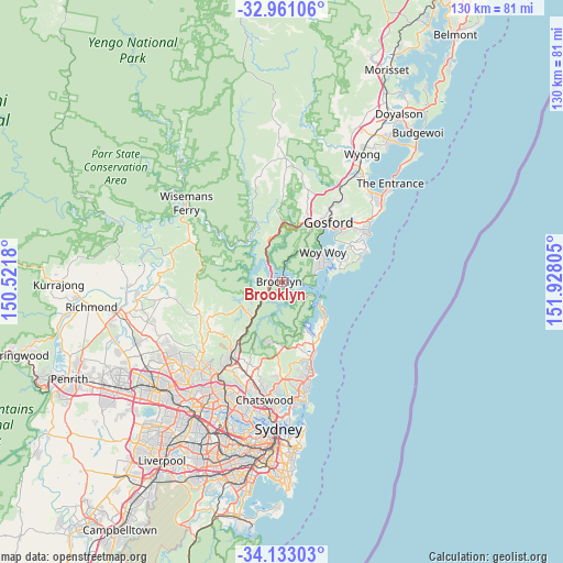
Brooklyn GPS coordinates[2]
33° 32' 56.508" South, 151° 13' 29.712" East
| Map corner | latitude | longitude |
|---|---|---|
| Upper-left | -32.96106°, | 150.5218° |
| Center: | -33.54903°, | 151.22492° |
| Lower-right: | -34.13303°, | 151.92805° |
| Map W x H: | 130.3×130.3 km | = 81×81mi |
| max Lat: | -10.58257° ⇑47% North |
| Brooklyn: | -33.54903° |
| min Lat: | ⇓53% South -43.31423° |
| min Long | Brooklyn | max Long |
| 113.53327° | 151.22492° | 153.61246° |
| W 73.9%⇐ | ⇒26.1% E |
Elevation
Elevation of Brooklyn is 37 m = 121 ft, and this is 85 m = 279 ft below average elevation for this country.
| Max E: |
1715 m = 5627 ft | 55.9% |
| Avg. | 122 m = 400 ft | |
| Brooklyn | 37 m = 121 ft | |
Min E: |
-2 m = -7 ft | 44.1% |
See also: Australia elevation on elevation.city.
Geographical zone
Brooklyn is located in South temperate zone (between Tropic of Capricorn and the Antarctic Circle). Distance of this Southern Tropic circle is 1124.4 km =698.7 mi to North.| Distance of | km | miles | from Brooklyn |
|---|---|---|---|
| Equator | 3730.3 | 2317.9 | to North |
| Tropic Capricorn | 1124.4 | 698.7 | to North |
| Antarctic Circle | 3670.9 | 2281 | to South |
| South Pole | 6276.8 | 3900.2 | to South |


Nearby cities:
15 places around Brooklyn: (largest is in red/bold)
• Berowra
10.5 km =6.5 mi,  220°
220°
• Berowra Heights
10.7 km =6.6 mi,  229°
229°
• Blackwall
10.9 km =6.8 mi,  61°
61°
• Booker Bay
11.9 km =7.4 mi,  70°
70°
• Church Point
12 km =7.5 mi,  153°
153°
• Clareville
12.4 km =7.7 mi,  136°
136°
• Cowan
7.3 km =4.5 mi, 225°
• Ettalong
11.2 km =7 mi, 69°
• Ettalong Beach
10.7 km =6.6 mi, 66°
• Horsfield Bay
9.5 km =5.9 mi,  48°
48°
• Palm Beach
10.6 km =6.6 mi,  120°
120°
• Pearl Beach
7.3 km =4.5 mi,  85°
85°
• Scotland Island
11.7 km =7.3 mi, 150°
• Umina Beach
8.7 km =5.4 mi, 70°
• Woy Woy
11.7 km =7.3 mi, 52°
Sources, notices
• [Note1] Compared only with cities in Australia existing in our database
• [Src1] Map data: © OpenStreetMap contributors (CC-BY-SA)
• [Src2] Other city data from geonames.org with taken over terms of usage.
• [Src3] Geographical zone / Annual Mean Temperature by Robert A. Rohde @ Wikipedia
