Cowan geodata
Cowan (New South Wales) is a section of populated place; located in Australia in Australia/Sydney (GMT+11) time zone. With population of 644 people, there are 4460 cities with bigger population in this country. Compared to other cities in Australia, 52.7% of cities are located further ↓South; 72.3% of cities are located further ←West and 77.1% of cities have lower elevation than Cowan. Note1


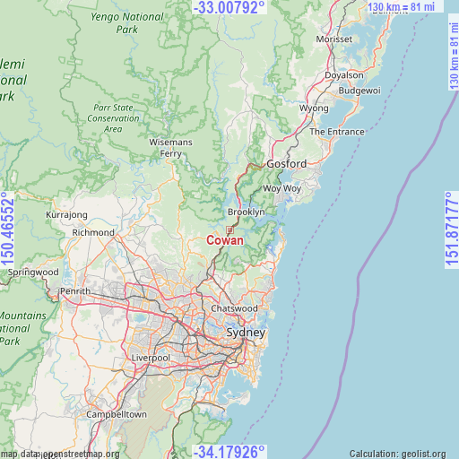
Cowan GPS coordinates[2]
33° 35' 44.088" South, 151° 10' 7.104" East
| Map corner | latitude | longitude |
|---|---|---|
| Upper-left | -33.00792°, | 150.46552° |
| Center: | -33.59558°, | 151.16864° |
| Lower-right: | -34.17926°, | 151.87177° |
| Map W x H: | 130.2×130.2 km | = 80.9×80.9mi |
| max Lat: | -10.58257° ⇑47.3% North |
| Cowan: | -33.59558° |
| min Lat: | ⇓52.7% South -43.31423° |
| min Long | Cowan | max Long |
| 113.53327° | 151.16864° | 153.61246° |
| W 72.3%⇐ | ⇒27.7% E |
Elevation
Elevation of Cowan is 149 m = 489 ft, and this is 27 m = 89 ft above average elevation for this country.
| Max E: |
1715 m = 5627 ft | 22.9% |
| Cowan | 149 m 489 ft | |
| Avg. | 122 m = 400 ft | |
Min E: |
-2 m = -7 ft | 77.1% |
See also: Australia elevation on elevation.city.
Geographical zone
Cowan is located in South temperate zone (between Tropic of Capricorn and the Antarctic Circle). Distance of this Southern Tropic circle is 1129.6 km =701.9 mi to North.| Distance of | km | miles | from Cowan |
|---|---|---|---|
| Equator | 3735.5 | 2321.1 | to North |
| Tropic Capricorn | 1129.6 | 701.9 | to North |
| Antarctic Circle | 3665.7 | 2277.8 | to South |
| South Pole | 6271.6 | 3897 | to South |


Nearby cities:
15 places around Cowan: (largest is in red/bold)
• Arcadia
12.7 km =7.9 mi,  259°
259°
• Asquith
11.3 km =7 mi,  205°
205°
• Berowra
3.2 km =2 mi, 210°
• Berowra Heights
3.4 km =2.1 mi,  237°
237°
• Brooklyn
7.3 km =4.5 mi,  45°
45°
• Church Point
12 km =7.5 mi,  117°
117°
• Galston
12.9 km =8 mi, 240°
• Hornsby Heights
10.9 km =6.8 mi,  219°
219°
• Ingleside
13.2 km =8.2 mi,  138°
138°
• Mount Colah
10.9 km =6.8 mi, 206°
• Mount Kuring-Gai
6.3 km =3.9 mi, 215°
• North Wahroonga
12.9 km =8 mi,  199°
199°
• Scotland Island
12.1 km =7.5 mi,  114°
114°
• St Ives Chase
12 km =7.5 mi,  181°
181°
• Terry Hills
11.4 km =7.1 mi,  148°
148°
Sources, notices
• [Note1] Compared only with cities in Australia existing in our database
• [Src1] Map data: © OpenStreetMap contributors (CC-BY-SA)
• [Src2] Other city data from geonames.org with taken over terms of usage.
• [Src3] Geographical zone / Annual Mean Temperature by Robert A. Rohde @ Wikipedia
