Mount Kuring-Gai geodata
Mount Kuring-Gai (New South Wales) is a section of populated place; located in Australia in Australia/Sydney (GMT+11) time zone. With population of 1,693 people, there are 3108 cities with bigger population in this country. Compared to other cities in Australia, 52.2% of cities are located further ↓South; 71% of cities are located further ←West and 82.6% of cities have lower elevation than Mount Kuring-Gai. Note1


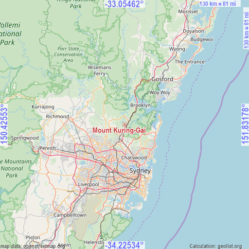
Mount Kuring-Gai GPS coordinates[2]
33° 38' 31.092" South, 151° 7' 43.14" East
| Map corner | latitude | longitude |
|---|---|---|
| Upper-left | -33.05462°, | 150.42553° |
| Center: | -33.64197°, | 151.12865° |
| Lower-right: | -34.22534°, | 151.83178° |
| Map W x H: | 130.2×130.2 km | = 80.9×80.9mi |
| max Lat: | -10.58257° ⇑47.8% North |
| Mount Kuring-Gai: | -33.64197° |
| min Lat: | ⇓52.2% South -43.31423° |
| min Long | Mount Kuring-Ga | max Long |
| 113.53327° | 151.12865° | 153.61246° |
| W 71%⇐ | ⇒29% E |
Elevation
Elevation of Mount Kuring-Gai is 213 m = 699 ft, and this is 91 m = 299 ft above average elevation for this country.
| Max E: |
1715 m = 5627 ft | 17.4% |
| Mount Kuring-Gai | 213 m 699 ft | |
| Avg. | 122 m = 400 ft | |
Min E: |
-2 m = -7 ft | 82.6% |
See also: Australia elevation on elevation.city.
Geographical zone
Mount Kuring-Gai is located in South temperate zone (between Tropic of Capricorn and the Antarctic Circle). Distance of this Southern Tropic circle is 1134.7 km =705.1 mi to North.| Distance of | km | miles | from Mount Kuring-Gai |
|---|---|---|---|
| Equator | 3740.6 | 2324.3 | to North |
| Tropic Capricorn | 1134.7 | 705.1 | to North |
| Antarctic Circle | 3660.5 | 2274.5 | to South |
| South Pole | 6266.4 | 3893.8 | to South |


Nearby cities:
15 places around Mount Kuring-Gai: (largest is in red/bold)
• Arcadia
9.3 km =5.8 mi,  287°
287°
• Asquith
5.1 km =3.2 mi,  192°
192°
• Berowra
3.1 km =1.9 mi,  41°
41°
• Berowra Heights
3.4 km =2.1 mi,  13°
13°
• Cowan
6.3 km =3.9 mi, 35°
• Galston
7.6 km =4.7 mi,  260°
260°
• Hornsby
7.3 km =4.5 mi,  201°
201°
• Hornsby Heights
4.6 km =2.9 mi,  224°
224°
• Mount Colah
4.7 km =2.9 mi, 193°
• North Turramurra
8.1 km =5 mi,  168°
168°
• North Wahroonga
7.1 km =4.4 mi,  184°
184°
• St Ives Chase
7.6 km =4.7 mi,  154°
154°
• Wahroonga
8.6 km =5.3 mi, 188°
• Waitara
8 km =5 mi, 197°
• Westleigh
9.4 km =5.8 mi,  214°
214°
Sources, notices
• [Note1] Compared only with cities in Australia existing in our database
• [Src1] Map data: © OpenStreetMap contributors (CC-BY-SA)
• [Src2] Other city data from geonames.org with taken over terms of usage.
• [Src3] Geographical zone / Annual Mean Temperature by Robert A. Rohde @ Wikipedia
