Agnes Water geodata
Agnes Water (Queensland) is a populated place; located in Australia in Australia/Brisbane (GMT+10) time zone. With population of 2,521 people, there are 2553 cities with bigger population in this country. Compared to other cities in Australia, 90.6% of cities are located further ↓South; 81.9% of cities are located further ←West and 79% of cities have higher elevation than Agnes Water. Note1


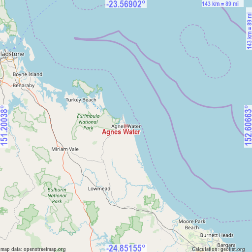
Agnes Water GPS coordinates[2]
24° 12' 42.84" South, 151° 54' 12.6" East
| Map corner | latitude | longitude |
|---|---|---|
| Upper-left | -23.56902°, | 151.20038° |
| Center: | -24.2119°, | 151.9035° |
| Lower-right: | -24.85155°, | 152.60663° |
| Map W x H: | 142.6×142.6 km | = 88.6×88.6mi |
| max Lat: | -10.58257° ⇑9.4% North |
| Agnes Water: | -24.2119° |
| min Lat: | ⇓90.6% South -43.31423° |
| min Long | Agnes Water | max Long |
| 113.53327° | 151.9035° | 153.61246° |
| W 81.9%⇐ | ⇒18.1% E |
Elevation
Elevation of Agnes Water is 16 m = 52 ft, and this is 106 m = 348 ft below average elevation for this country.
| Max E: |
1715 m = 5627 ft | 79% |
| Avg. | 122 m = 400 ft | |
| Agnes Water | 16 m = 52 ft | |
Min E: |
-2 m = -7 ft | 21% |
See also: Australia elevation on elevation.city.
Geographical zone
Agnes Water is located in South temperate zone (between Tropic of Capricorn and the Antarctic Circle). Distance of this Southern Tropic circle is 86.2 km =53.6 mi to North.| Distance of | km | miles | from Agnes Water |
|---|---|---|---|
| Equator | 2692.1 | 1672.8 | to North |
| Tropic Capricorn | 86.2 | 53.6 | to North |
| Antarctic Circle | 4709.1 | 2926.1 | to South |
| South Pole | 7315 | 4545.3 | to South |


Nearby cities:
15 places around Agnes Water: (largest is in red/bold)
• Avondale
64 km =39.8 mi,  156°
156°
• Benaraby
62.2 km =38.6 mi,  291°
291°
• Boyne Island
63.1 km =39.2 mi,  297°
297°
• Bucca
75.5 km =46.9 mi, 164°
• Burua
75.6 km =47 mi, 292°
• Calliope
74.9 km =46.5 mi, 287°
• Glen Eden
73.1 km =45.4 mi, 298°
• Kirkwood
76 km =47.2 mi, 296°
• Miriam Vale
37 km =23 mi,  248°
248°
• Moore Park Beach
63.5 km =39.5 mi,  150°
150°
• South Gladstone
75.3 km =46.8 mi, 301°
• Sun Valley
75.5 km =46.9 mi, 299°
• Tannum Sands
61.8 km =38.4 mi, 298°
• Telina
75.1 km =46.7 mi, 298°
• Toolooa
74.1 km =46 mi, 299°
Sources, notices
• [Note1] Compared only with cities in Australia existing in our database
• [Src1] Map data: © OpenStreetMap contributors (CC-BY-SA)
• [Src2] Other city data from geonames.org with taken over terms of usage.
• [Src3] Geographical zone / Annual Mean Temperature by Robert A. Rohde @ Wikipedia
