Connolly geodata
Connolly (Western Australia) is a section of populated place; located in Australia in Australia/Perth (GMT+8) time zone. With population of 3,586 people, there are 1961 cities with bigger population in this country. Compared to other cities in Australia, 68.6% of cities are located further ↓South; 97.6% of cities are located further →East and 62.8% of cities have higher elevation than Connolly. Note1


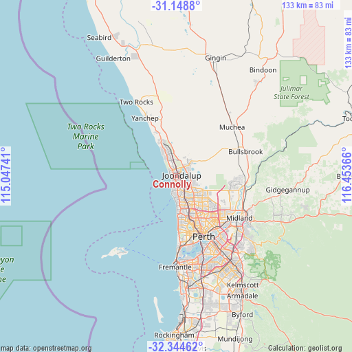
Connolly GPS coordinates[2]
31° 44' 55.104" South, 115° 45' 1.908" East
| Map corner | latitude | longitude |
|---|---|---|
| Upper-left | -31.1488°, | 115.04741° |
| Center: | -31.74864°, | 115.75053° |
| Lower-right: | -32.34462°, | 116.45366° |
| Map W x H: | 133×133 km | = 82.6×82.6mi |
| max Lat: | -10.58257° ⇑31.4% North |
| Connolly: | -31.74864° |
| min Lat: | ⇓68.6% South -43.31423° |
| min Long | Connolly | max Long |
| 113.53327° | 115.75053° | 153.61246° |
| W 2.4%⇐ | ⇒97.6% E |
Elevation
Elevation of Connolly is 29 m = 95 ft, and this is 93 m = 305 ft below average elevation for this country.
| Max E: |
1715 m = 5627 ft | 62.8% |
| Avg. | 122 m = 400 ft | |
| Connolly | 29 m = 95 ft | |
Min E: |
-2 m = -7 ft | 37.2% |
See also: Australia elevation on elevation.city.
Geographical zone
Connolly is located in South temperate zone (between Tropic of Capricorn and the Antarctic Circle). Distance of this Southern Tropic circle is 924.2 km =574.3 mi to North.| Distance of | km | miles | from Connolly |
|---|---|---|---|
| Equator | 3530.1 | 2193.5 | to North |
| Tropic Capricorn | 924.2 | 574.3 | to North |
| Antarctic Circle | 3871.1 | 2405.4 | to South |
| South Pole | 6476.9 | 4024.6 | to South |


Nearby cities:
15 places around Connolly: (largest is in red/bold)
• Ashby
4.8 km =3 mi,  68°
68°
• Beldon
3.1 km =1.9 mi,  158°
158°
• Burns Beach
4.2 km =2.6 mi,  317°
317°
• Craigie
4.7 km =2.9 mi, 156°
• Currambine
1.8 km =1.1 mi,  351°
351°
• Edgewater
3.5 km =2.2 mi,  121°
121°
• Heathridge
1.7 km =1.1 mi,  152°
152°
• Iluka
2.4 km =1.5 mi,  307°
307°
• Joondalup
1.7 km =1.1 mi, 74°
• Kallaroo
4.7 km =2.9 mi,  177°
177°
• Kinross
3.5 km =2.2 mi,  340°
340°
• Mullaloo
3.6 km =2.2 mi,  201°
201°
• Ocean Reef
1.8 km =1.1 mi,  230°
230°
• Sinagra
5.3 km =3.3 mi,  82°
82°
• Wanneroo
4.7 km =2.9 mi,  91°
91°
Sources, notices
• [Note1] Compared only with cities in Australia existing in our database
• [Src1] Map data: © OpenStreetMap contributors (CC-BY-SA)
• [Src2] Other city data from geonames.org with taken over terms of usage.
• [Src3] Geographical zone / Annual Mean Temperature by Robert A. Rohde @ Wikipedia
