Currambine geodata
Currambine (Western Australia) is a section of populated place; located in Australia in Australia/Perth (GMT+8) time zone. With population of 6,771 people, there are 1014 cities with bigger population in this country. Compared to other cities in Australia, 68.7% of cities are located further ↓South; 97.6% of cities are located further →East and 56.9% of cities have lower elevation than Currambine. Note1


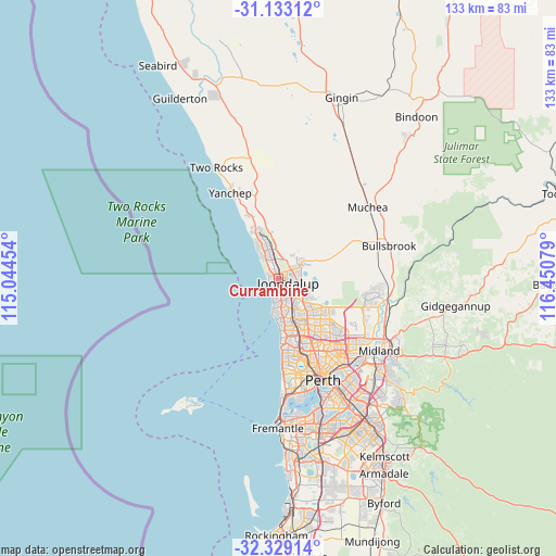
Currambine GPS coordinates[2]
31° 43' 59.016" South, 115° 44' 51.576" East
| Map corner | latitude | longitude |
|---|---|---|
| Upper-left | -31.13312°, | 115.04454° |
| Center: | -31.73306°, | 115.74766° |
| Lower-right: | -32.32914°, | 116.45079° |
| Map W x H: | 133×133 km | = 82.6×82.6mi |
| max Lat: | -10.58257° ⇑31.3% North |
| Currambine: | -31.73306° |
| min Lat: | ⇓68.7% South -43.31423° |
| min Long | Currambine | max Long |
| 113.53327° | 115.74766° | 153.61246° |
| W 2.4%⇐ | ⇒97.6% E |
Elevation
Elevation of Currambine is 57 m = 187 ft, and this is 65 m = 213 ft below average elevation for this country.
| Max E: |
1715 m = 5627 ft | 43.1% |
| Avg. | 122 m = 400 ft | |
| Currambine | 57 m = 187 ft | |
Min E: |
-2 m = -7 ft | 56.9% |
See also: Australia elevation on elevation.city.
Geographical zone
Currambine is located in South temperate zone (between Tropic of Capricorn and the Antarctic Circle). Distance of this Southern Tropic circle is 922.5 km =573.2 mi to North.| Distance of | km | miles | from Currambine |
|---|---|---|---|
| Equator | 3528.4 | 2192.4 | to North |
| Tropic Capricorn | 922.5 | 573.2 | to North |
| Antarctic Circle | 3872.8 | 2406.4 | to South |
| South Pole | 6478.7 | 4025.7 | to South |


Nearby cities:
15 places around Currambine: (largest is in red/bold)
• Ashby
4.7 km =2.9 mi,  89°
89°
• Beldon
4.8 km =3 mi,  162°
162°
• Burns Beach
2.9 km =1.8 mi,  298°
298°
• Carramar
5.3 km =3.3 mi,  25°
25°
• Connolly
1.8 km =1.1 mi,  171°
171°
• Edgewater
4.9 km =3 mi,  137°
137°
• Heathridge
3.4 km =2.1 mi, 161°
• Iluka
1.6 km =1 mi,  260°
260°
• Joondalup
2.3 km =1.4 mi,  122°
122°
• Kinross
1.8 km =1.1 mi,  331°
331°
• Mullaloo
5.2 km =3.2 mi,  191°
191°
• Ocean Reef
3.1 km =1.9 mi,  201°
201°
• Sinagra
5.6 km =3.5 mi,  100°
100°
• Tapping
4.8 km =3 mi,  71°
71°
• Wanneroo
5.3 km =3.3 mi,  110°
110°
Sources, notices
• [Note1] Compared only with cities in Australia existing in our database
• [Src1] Map data: © OpenStreetMap contributors (CC-BY-SA)
• [Src2] Other city data from geonames.org with taken over terms of usage.
• [Src3] Geographical zone / Annual Mean Temperature by Robert A. Rohde @ Wikipedia
