Kettering geodata
Kettering (Tasmania) is a populated place; located in Australia in Australia/Hobart (GMT+11) time zone. With population of 769 people, there are 4206 cities with bigger population in this country. Compared to other cities in Australia, 99.9% of cities are located further ↑North; 51.7% of cities are located further →East and 77.5% of cities have higher elevation than Kettering. Note1


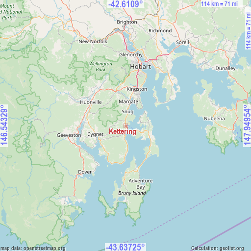
Kettering GPS coordinates[2]
43° 7' 34.428" South, 147° 14' 47.076" East
| Map corner | latitude | longitude |
|---|---|---|
| Upper-left | -42.6109°, | 146.54329° |
| Center: | -43.12623°, | 147.24641° |
| Lower-right: | -43.63725°, | 147.94954° |
| Map W x H: | 114.1×114.1 km | = 70.9×70.9mi |
| max Lat: | -10.58257° ⇑99.9% North |
| Kettering: | -43.12623° |
| min Lat: | ⇓0.1% South -43.31423° |
| min Long | Kettering | max Long |
| 113.53327° | 147.24641° | 153.61246° |
| W 48.3%⇐ | ⇒51.7% E |
Elevation
Elevation of Kettering is 17 m = 56 ft, and this is 105 m = 344 ft below average elevation for this country.
| Max E: |
1715 m = 5627 ft | 77.5% |
| Avg. | 122 m = 400 ft | |
| Kettering | 17 m = 56 ft | |
Min E: |
-2 m = -7 ft | 22.5% |
See also: Australia elevation on elevation.city.
Geographical zone
Kettering is located in South temperate zone (between Tropic of Capricorn and the Antarctic Circle). Distance of this Southern Tropic circle is 2189.3 km =1360.4 mi to North.| Distance of | km | miles | from Kettering |
|---|---|---|---|
| Equator | 4795.2 | 2979.6 | to North |
| Tropic Capricorn | 2189.3 | 1360.4 | to North |
| Antarctic Circle | 2606 | 1619.3 | to South |
| South Pole | 5211.9 | 3238.5 | to South |


Nearby cities:
15 places around Kettering: (largest is in red/bold)
• Blackmans Bay
14.8 km =9.2 mi,  22°
22°
• Cygnet
14.4 km =8.9 mi,  257°
257°
• Fern Tree
22.9 km =14.2 mi,  3°
3°
• Franklin
19.7 km =12.2 mi,  282°
282°
• Howden
11.9 km =7.4 mi, 18°
• Huonville
19.3 km =12 mi,  303°
303°
• Kingston
17.3 km =10.7 mi, 15°
• Kingston Beach
17.3 km =10.7 mi, 20°
• Margate
11 km =6.8 mi,  6°
6°
• Mount Nelson
23.6 km =14.7 mi, 14°
• Mountain River
21.8 km =13.5 mi,  335°
335°
• Ranelagh
21.3 km =13.2 mi,  307°
307°
• Snug
6.7 km =4.2 mi, 5°
• South Arm
18.1 km =11.2 mi,  52°
52°
• Taroona
21.8 km =13.5 mi, 22°
Sources, notices
• [Note1] Compared only with cities in Australia existing in our database
• [Src1] Map data: © OpenStreetMap contributors (CC-BY-SA)
• [Src2] Other city data from geonames.org with taken over terms of usage.
• [Src3] Geographical zone / Annual Mean Temperature by Robert A. Rohde @ Wikipedia
