Kalaru geodata
Kalaru (New South Wales) is a populated place; located in Australia in Australia/Sydney (GMT+11) time zone. With population of 669 people, there are 4384 cities with bigger population in this country. Compared to other cities in Australia, 80.6% of cities are located further ↑North; 56.8% of cities are located further ←West and 50.2% of cities have lower elevation than Kalaru. Note1


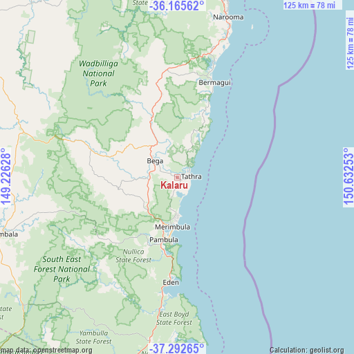
Kalaru GPS coordinates[2]
36° 43' 52.32" South, 149° 55' 45.84" East
| Map corner | latitude | longitude |
|---|---|---|
| Upper-left | -36.16562°, | 149.22628° |
| Center: | -36.7312°, | 149.9294° |
| Lower-right: | -37.29265°, | 150.63253° |
| Map W x H: | 125.3×125.3 km | = 77.9×77.9mi |
| max Lat: | -10.58257° ⇑80.6% North |
| Kalaru: | -36.7312° |
| min Lat: | ⇓19.4% South -43.31423° |
| min Long | Kalaru | max Long |
| 113.53327° | 149.9294° | 153.61246° |
| W 56.8%⇐ | ⇒43.2% E |
Elevation
Elevation of Kalaru is 46 m = 151 ft, and this is 76 m = 249 ft below average elevation for this country.
| Max E: |
1715 m = 5627 ft | 49.8% |
| Avg. | 122 m = 400 ft | |
| Kalaru | 46 m = 151 ft | |
Min E: |
-2 m = -7 ft | 50.2% |
See also: Australia elevation on elevation.city.
Geographical zone
Kalaru is located in South temperate zone (between Tropic of Capricorn and the Antarctic Circle). Distance of this Southern Tropic circle is 1478.2 km =918.5 mi to North.| Distance of | km | miles | from Kalaru |
|---|---|---|---|
| Equator | 4084.1 | 2537.7 | to North |
| Tropic Capricorn | 1478.2 | 918.5 | to North |
| Antarctic Circle | 3317 | 2061.1 | to South |
| South Pole | 5922.9 | 3680.3 | to South |


Nearby cities:
15 places around Kalaru: (largest is in red/bold)
• Bega
10.1 km =6.3 mi,  309°
309°
• Bemboka
33.9 km =21.1 mi,  289°
289°
• Bermagui
36.7 km =22.8 mi,  19°
19°
• Candelo
21.3 km =13.2 mi,  259°
259°
• Cobargo
38.4 km =23.9 mi,  354°
354°
• Eden
37.4 km =23.2 mi,  183°
183°
• Merimbula
17.6 km =10.9 mi,  185°
185°
• Narooma
59.9 km =37.2 mi, 17°
• North Narooma
61 km =37.9 mi, 15°
• Pambula
22.6 km =14 mi, 192°
• Pambula Beach
23.5 km =14.6 mi, 185°
• Tathra
4.8 km =3 mi,  90°
90°
• Tura Beach
14.7 km =9.1 mi, 179°
• Wallaga Lake
40.3 km =25 mi, 17°
• Wolumla
15.2 km =9.4 mi,  223°
223°
Sources, notices
• [Note1] Compared only with cities in Australia existing in our database
• [Src1] Map data: © OpenStreetMap contributors (CC-BY-SA)
• [Src2] Other city data from geonames.org with taken over terms of usage.
• [Src3] Geographical zone / Annual Mean Temperature by Robert A. Rohde @ Wikipedia
