Pambula Beach geodata
Pambula Beach (New South Wales) is a populated place; located in Australia in Australia/Sydney (GMT+11) time zone. With population of 662 people, there are 4403 cities with bigger population in this country. Compared to other cities in Australia, 81.4% of cities are located further ↑North; 56.8% of cities are located further ←West and 74.7% of cities have higher elevation than Pambula Beach. Note1


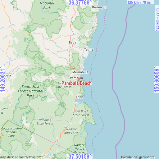
Pambula Beach GPS coordinates[2]
36° 56' 30.12" South, 149° 54' 12.348" East
| Map corner | latitude | longitude |
|---|---|---|
| Upper-left | -36.37766°, | 149.20031° |
| Center: | -36.9417°, | 149.90343° |
| Lower-right: | -37.50159°, | 150.60656° |
| Map W x H: | 125×125 km | = 77.7×77.7mi |
| max Lat: | -10.58257° ⇑81.4% North |
| Pambula Beach: | -36.9417° |
| min Lat: | ⇓18.6% South -43.31423° |
| min Long | Pambula Beach | max Long |
| 113.53327° | 149.90343° | 153.61246° |
| W 56.8%⇐ | ⇒43.2% E |
Elevation
Elevation of Pambula Beach is 19 m = 62 ft, and this is 103 m = 338 ft below average elevation for this country.
| Max E: |
1715 m = 5627 ft | 74.7% |
| Avg. | 122 m = 400 ft | |
| Pambula Beach | 19 m = 62 ft | |
Min E: |
-2 m = -7 ft | 25.3% |
See also: Australia elevation on elevation.city.
Geographical zone
Pambula Beach is located in South temperate zone (between Tropic of Capricorn and the Antarctic Circle). Distance of this Southern Tropic circle is 1501.6 km =933.1 mi to North.| Distance of | km | miles | from Pambula Beach |
|---|---|---|---|
| Equator | 4107.5 | 2552.3 | to North |
| Tropic Capricorn | 1501.6 | 933.1 | to North |
| Antarctic Circle | 3293.6 | 2046.5 | to South |
| South Pole | 5899.5 | 3665.8 | to South |


Nearby cities:
15 places around Pambula Beach: (largest is in red/bold)
• Bega
30.3 km =18.8 mi,  349°
349°
• Bemboka
45.6 km =28.3 mi,  319°
319°
• Bermagui
59.8 km =37.2 mi,  13°
13°
• Bombala
59.4 km =36.9 mi,  273°
273°
• Candelo
26.8 km =16.7 mi, 316°
• Cobargo
61.6 km =38.3 mi,  358°
358°
• Eden
13.9 km =8.6 mi,  181°
181°
• Kalaru
23.5 km =14.6 mi, 5°
• Mallacoota
69.9 km =43.4 mi,  190°
190°
• Merimbula
5.9 km =3.7 mi, 5°
• Pambula
2.9 km =1.8 mi,  296°
296°
• Tathra
24.5 km =15.2 mi,  16°
16°
• Tura Beach
9 km =5.6 mi, 15°
• Wallaga Lake
63.5 km =39.5 mi, 13°
• Wolumla
14.7 km =9.1 mi,  326°
326°
Sources, notices
• [Note1] Compared only with cities in Australia existing in our database
• [Src1] Map data: © OpenStreetMap contributors (CC-BY-SA)
• [Src2] Other city data from geonames.org with taken over terms of usage.
• [Src3] Geographical zone / Annual Mean Temperature by Robert A. Rohde @ Wikipedia
