Millgrove geodata
Millgrove (Victoria) is a section of populated place; located in Australia in Australia/Melbourne (GMT+11) time zone. With population of 1,587 people, there are 3204 cities with bigger population in this country. Compared to other cities in Australia, 86.2% of cities are located further ↑North; 58.9% of cities are located further →East and 76.2% of cities have lower elevation than Millgrove. Note1


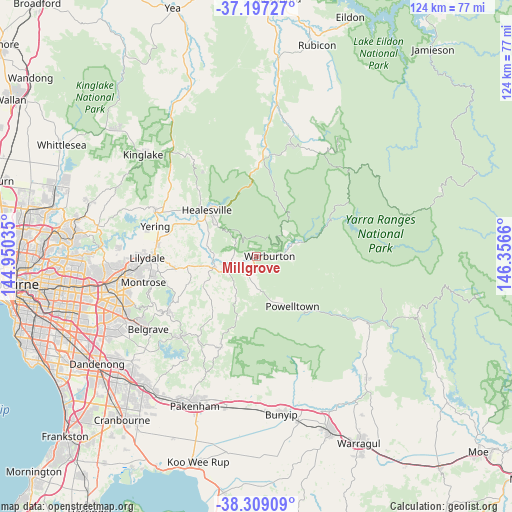
Millgrove GPS coordinates[2]
37° 45' 18.972" South, 145° 39' 12.492" East
| Map corner | latitude | longitude |
|---|---|---|
| Upper-left | -37.19727°, | 144.95035° |
| Center: | -37.75527°, | 145.65347° |
| Lower-right: | -38.30909°, | 146.3566° |
| Map W x H: | 123.6×123.6 km | = 76.8×76.8mi |
| max Lat: | -10.58257° ⇑86.2% North |
| Millgrove: | -37.75527° |
| min Lat: | ⇓13.8% South -43.31423° |
| min Long | Millgrove | max Long |
| 113.53327° | 145.65347° | 153.61246° |
| W 41.1%⇐ | ⇒58.9% E |
Elevation
Elevation of Millgrove is 140 m = 459 ft, and this is 18 m = 59 ft above average elevation for this country.
| Max E: |
1715 m = 5627 ft | 23.8% |
| Millgrove | 140 m 459 ft | |
| Avg. | 122 m = 400 ft | |
Min E: |
-2 m = -7 ft | 76.2% |
See also: Australia elevation on elevation.city.
Geographical zone
Millgrove is located in South temperate zone (between Tropic of Capricorn and the Antarctic Circle). Distance of this Southern Tropic circle is 1592.1 km =989.3 mi to North.| Distance of | km | miles | from Millgrove |
|---|---|---|---|
| Equator | 4198 | 2608.5 | to North |
| Tropic Capricorn | 1592.1 | 989.3 | to North |
| Antarctic Circle | 3203.2 | 1990.4 | to South |
| South Pole | 5809.1 | 3609.6 | to South |


Nearby cities:
15 places around Millgrove: (largest is in red/bold)
• Badger Creek
13.5 km =8.4 mi,  297°
297°
• Don Valley
5.8 km =3.6 mi,  291°
291°
• East Warburton
8.1 km =5 mi,  75°
75°
• Gruyere
18.1 km =11.2 mi,  277°
277°
• Healesville
16.5 km =10.3 mi,  313°
313°
• Hoddles Creek
10.6 km =6.6 mi,  215°
215°
• Launching Place
8 km =5 mi,  249°
249°
• Seville
15.3 km =9.5 mi, 251°
• Seville East
13.9 km =8.6 mi,  260°
260°
• Wandin North
19.6 km =12.2 mi, 260°
• Warburton
3.2 km =2 mi,  87°
87°
• Wesburn
2.2 km =1.4 mi,  234°
234°
• Woori Yallock
10.5 km =6.5 mi, 254°
• Yarra Junction
4.5 km =2.8 mi, 229°
• Yellingbo
14.9 km =9.3 mi, 227°
Sources, notices
• [Note1] Compared only with cities in Australia existing in our database
• [Src1] Map data: © OpenStreetMap contributors (CC-BY-SA)
• [Src2] Other city data from geonames.org with taken over terms of usage.
• [Src3] Geographical zone / Annual Mean Temperature by Robert A. Rohde @ Wikipedia
