Waterview Heights geodata
Waterview Heights (New South Wales) is a populated place; located in Australia in Australia/Sydney (GMT+11) time zone. With population of 1,327 people, there are 3453 cities with bigger population in this country. Compared to other cities in Australia, 72.6% of cities are located further ↓South; 87.5% of cities are located further ←West and 53.5% of cities have lower elevation than Waterview Heights. Note1


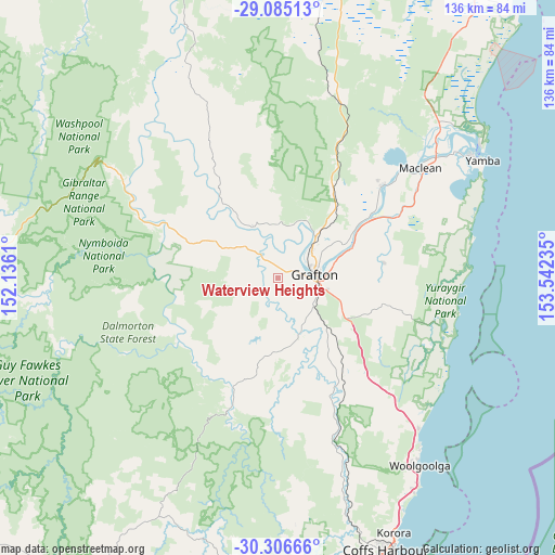
Waterview Heights GPS coordinates[2]
29° 41' 51.9" South, 152° 50' 21.192" East
| Map corner | latitude | longitude |
|---|---|---|
| Upper-left | -29.08513°, | 152.1361° |
| Center: | -29.69775°, | 152.83922° |
| Lower-right: | -30.30666°, | 153.54235° |
| Map W x H: | 135.8×135.8 km | = 84.4×84.4mi |
| max Lat: | -10.58257° ⇑27.4% North |
| Waterview Heights: | -29.69775° |
| min Lat: | ⇓72.6% South -43.31423° |
| min Long | Waterview Heigh | max Long |
| 113.53327° | 152.83922° | 153.61246° |
| W 87.5%⇐ | ⇒12.5% E |
Elevation
Elevation of Waterview Heights is 50 m = 164 ft, and this is 72 m = 236 ft below average elevation for this country.
| Max E: |
1715 m = 5627 ft | 46.5% |
| Avg. | 122 m = 400 ft | |
| Waterview Heights | 50 m = 164 ft | |
Min E: |
-2 m = -7 ft | 53.5% |
See also: Australia elevation on elevation.city.
Geographical zone
Waterview Heights is located in South temperate zone (between Tropic of Capricorn and the Antarctic Circle). Distance of this Southern Tropic circle is 696.2 km =432.6 mi to North.| Distance of | km | miles | from Waterview Heights |
|---|---|---|---|
| Equator | 3302.1 | 2051.8 | to North |
| Tropic Capricorn | 696.2 | 432.6 | to North |
| Antarctic Circle | 4099.1 | 2547.1 | to South |
| South Pole | 6705 | 4166.3 | to South |


Nearby cities:
15 places around Waterview Heights: (largest is in red/bold)
• Clarenza
15.6 km =9.7 mi,  92°
92°
• Corindi
50.2 km =31.2 mi,  136°
136°
• Corindi Beach
48.7 km =30.3 mi, 136°
• Coutts Crossing
15.1 km =9.4 mi,  160°
160°
• Glenreagh
41.8 km =26 mi, 161°
• Grafton
9.3 km =5.8 mi,  78°
78°
• Gulmarrad
44.7 km =27.8 mi,  58°
58°
• Junction Hill
10.4 km =6.5 mi,  52°
52°
• Lawrence
33.8 km =21 mi, 47°
• Maclean
43.7 km =27.2 mi, 52°
• Nana Glen
51.4 km =31.9 mi, 160°
• Red Rock
49.1 km =30.5 mi,  130°
130°
• South Grafton
8.5 km =5.3 mi,  97°
97°
• Townsend
45 km =28 mi, 55°
• Ulmarra
19.9 km =12.4 mi,  68°
68°
Sources, notices
• [Note1] Compared only with cities in Australia existing in our database
• [Src1] Map data: © OpenStreetMap contributors (CC-BY-SA)
• [Src2] Other city data from geonames.org with taken over terms of usage.
• [Src3] Geographical zone / Annual Mean Temperature by Robert A. Rohde @ Wikipedia
