Gulmarrad geodata
Gulmarrad (New South Wales) is a populated place; located in Australia in Australia/Sydney (GMT+11) time zone. With population of 1,658 people, there are 3132 cities with bigger population in this country. Compared to other cities in Australia, 72.8% of cities are located further ↓South; 97.1% of cities are located further ←West and 83.5% of cities have higher elevation than Gulmarrad. Note1


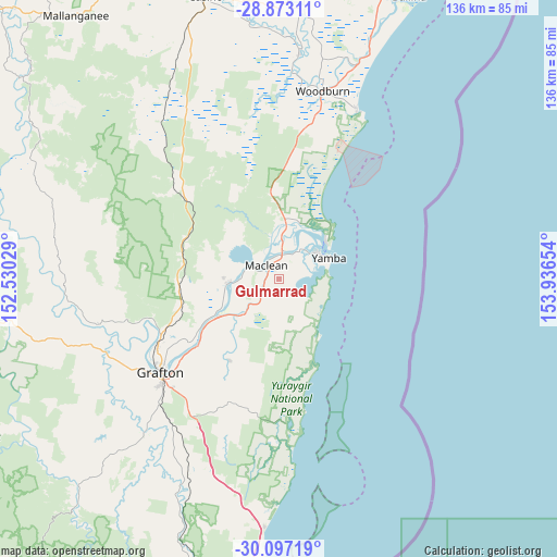
Gulmarrad GPS coordinates[2]
29° 29' 13.2" South, 153° 14' 0.276" East
| Map corner | latitude | longitude |
|---|---|---|
| Upper-left | -28.87311°, | 152.53029° |
| Center: | -29.487°, | 153.23341° |
| Lower-right: | -30.09719°, | 153.93654° |
| Map W x H: | 136.1×136.1 km | = 84.6×84.6mi |
| max Lat: | -10.58257° ⇑27.2% North |
| Gulmarrad: | -29.487° |
| min Lat: | ⇓72.8% South -43.31423° |
| min Long | Gulmarrad | max Long |
| 113.53327° | 153.23341° | 153.61246° |
| W 97.1%⇐ | ⇒2.9% E |
Elevation
Elevation of Gulmarrad is 13 m = 43 ft, and this is 109 m = 358 ft below average elevation for this country.
| Max E: |
1715 m = 5627 ft | 83.5% |
| Avg. | 122 m = 400 ft | |
| Gulmarrad | 13 m = 43 ft | |
Min E: |
-2 m = -7 ft | 16.5% |
See also: Australia elevation on elevation.city.
Geographical zone
Gulmarrad is located in South temperate zone (between Tropic of Capricorn and the Antarctic Circle). Distance of this Southern Tropic circle is 672.7 km =418 mi to North.| Distance of | km | miles | from Gulmarrad |
|---|---|---|---|
| Equator | 3278.6 | 2037.2 | to North |
| Tropic Capricorn | 672.7 | 418 | to North |
| Antarctic Circle | 4122.5 | 2561.6 | to South |
| South Pole | 6728.4 | 4180.8 | to South |


Nearby cities:
15 places around Gulmarrad: (largest is in red/bold)
• Clarenza
33 km =20.5 mi,  223°
223°
• Evans Head
45.3 km =28.1 mi,  24°
24°
• Grafton
36.1 km =22.4 mi,  233°
233°
• Iluka
14.8 km =9.2 mi,  50°
50°
• Junction Hill
34.4 km =21.4 mi,  240°
240°
• Lawrence
13.2 km =8.2 mi,  267°
267°
• Maclean
4.7 km =2.9 mi,  312°
312°
• Palmers Island
9.2 km =5.7 mi,  35°
35°
• South Grafton
38.5 km =23.9 mi, 230°
• Townsend
2.6 km =1.6 mi,  332°
332°
• Ulmarra
25.4 km =15.8 mi, 230°
• Waterview Heights
44.7 km =27.8 mi, 238°
• Woodburn
47.5 km =29.5 mi,  13°
13°
• Woombah
14.7 km =9.1 mi, 18°
• Yamba
13.4 km =8.3 mi,  65°
65°
Sources, notices
• [Note1] Compared only with cities in Australia existing in our database
• [Src1] Map data: © OpenStreetMap contributors (CC-BY-SA)
• [Src2] Other city data from geonames.org with taken over terms of usage.
• [Src3] Geographical zone / Annual Mean Temperature by Robert A. Rohde @ Wikipedia
