Clarenza geodata
Clarenza (New South Wales) is a section of populated place; located in Australia in Australia/Sydney (GMT+11) time zone. With population of 538 people, there are 4755 cities with bigger population in this country. Compared to other cities in Australia, 72.6% of cities are located further ↓South; 91.2% of cities are located further ←West and 59.2% of cities have higher elevation than Clarenza. Note1


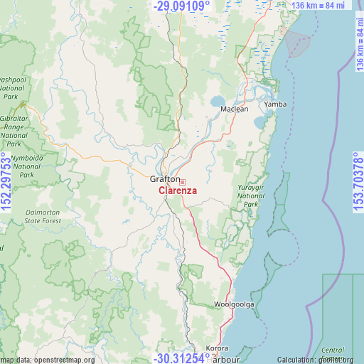
Clarenza GPS coordinates[2]
29° 42' 13.212" South, 153° 0' 2.34" East
| Map corner | latitude | longitude |
|---|---|---|
| Upper-left | -29.09109°, | 152.29753° |
| Center: | -29.70367°, | 153.00065° |
| Lower-right: | -30.31254°, | 153.70378° |
| Map W x H: | 135.8×135.8 km | = 84.4×84.4mi |
| max Lat: | -10.58257° ⇑27.4% North |
| Clarenza: | -29.70367° |
| min Lat: | ⇓72.6% South -43.31423° |
| min Long | Clarenza | max Long |
| 113.53327° | 153.00065° | 153.61246° |
| W 91.2%⇐ | ⇒8.8% E |
Elevation
Elevation of Clarenza is 33 m = 108 ft, and this is 89 m = 292 ft below average elevation for this country.
| Max E: |
1715 m = 5627 ft | 59.2% |
| Avg. | 122 m = 400 ft | |
| Clarenza | 33 m = 108 ft | |
Min E: |
-2 m = -7 ft | 40.8% |
See also: Australia elevation on elevation.city.
Geographical zone
Clarenza is located in South temperate zone (between Tropic of Capricorn and the Antarctic Circle). Distance of this Southern Tropic circle is 696.8 km =433 mi to North.| Distance of | km | miles | from Clarenza |
|---|---|---|---|
| Equator | 3302.7 | 2052.2 | to North |
| Tropic Capricorn | 696.8 | 433 | to North |
| Antarctic Circle | 4098.4 | 2546.6 | to South |
| South Pole | 6704.3 | 4165.9 | to South |


Nearby cities:
15 places around Clarenza: (largest is in red/bold)
• Corindi
40.5 km =25.2 mi,  152°
152°
• Corindi Beach
39.1 km =24.3 mi, 152°
• Coutts Crossing
17.2 km =10.7 mi,  217°
217°
• Glenreagh
38.9 km =24.2 mi,  183°
183°
• Grafton
6.9 km =4.3 mi,  291°
291°
• Gulmarrad
33 km =20.5 mi,  43°
43°
• Junction Hill
10.1 km =6.3 mi,  313°
313°
• Lawrence
25.3 km =15.7 mi,  21°
21°
• Maclean
33.3 km =20.7 mi,  34°
34°
• Palmers Island
42.1 km =26.2 mi, 41°
• Red Rock
38.1 km =23.7 mi, 145°
• South Grafton
7.2 km =4.5 mi,  266°
266°
• Townsend
33.9 km =21.1 mi, 38°
• Ulmarra
8.4 km =5.2 mi, 20°
• Waterview Heights
15.6 km =9.7 mi, 272°
Sources, notices
• [Note1] Compared only with cities in Australia existing in our database
• [Src1] Map data: © OpenStreetMap contributors (CC-BY-SA)
• [Src2] Other city data from geonames.org with taken over terms of usage.
• [Src3] Geographical zone / Annual Mean Temperature by Robert A. Rohde @ Wikipedia
