Corindi geodata
Corindi (New South Wales) is a populated place; located in Australia in Australia/Sydney (GMT+11) time zone. With population of 833 people, there are 4091 cities with bigger population in this country. Compared to other cities in Australia, 72.3% of cities are located further ↓South; 96.6% of cities are located further ←West and 73.6% of cities have higher elevation than Corindi. Note1


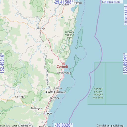
Corindi GPS coordinates[2]
30° 1' 32.556" South, 153° 11' 46.608" East
| Map corner | latitude | longitude |
|---|---|---|
| Upper-left | -29.41508°, | 152.49316° |
| Center: | -30.02571°, | 153.19628° |
| Lower-right: | -30.6326°, | 153.89941° |
| Map W x H: | 135.4×135.4 km | = 84.1×84.1mi |
| max Lat: | -10.58257° ⇑27.7% North |
| Corindi: | -30.02571° |
| min Lat: | ⇓72.3% South -43.31423° |
| min Long | Corindi | max Long |
| 113.53327° | 153.19628° | 153.61246° |
| W 96.6%⇐ | ⇒3.4% E |
Elevation
Elevation of Corindi is 20 m = 66 ft, and this is 102 m = 335 ft below average elevation for this country.
| Max E: |
1715 m = 5627 ft | 73.6% |
| Avg. | 122 m = 400 ft | |
| Corindi | 20 m = 66 ft | |
Min E: |
-2 m = -7 ft | 26.4% |
See also: Australia elevation on elevation.city.
Geographical zone
Corindi is located in South temperate zone (between Tropic of Capricorn and the Antarctic Circle). Distance of this Southern Tropic circle is 732.6 km =455.2 mi to North.| Distance of | km | miles | from Corindi |
|---|---|---|---|
| Equator | 3338.5 | 2074.4 | to North |
| Tropic Capricorn | 732.6 | 455.2 | to North |
| Antarctic Circle | 4062.6 | 2524.4 | to South |
| South Pole | 6668.5 | 4143.6 | to South |


Nearby cities:
15 places around Corindi: (largest is in red/bold)
• Arrawarra
3.9 km =2.4 mi,  187°
187°
• Arrawarra Headland
5 km =3.1 mi,  178°
178°
• Bucca
17.5 km =10.9 mi,  213°
213°
• Coramba
27.9 km =17.3 mi,  219°
219°
• Corindi Beach
1.4 km =0.9 mi,  314°
314°
• Emerald Beach
15.4 km =9.6 mi, 185°
• Glenreagh
21.2 km =13.2 mi,  261°
261°
• Korora
25.7 km =16 mi,  197°
197°
• Moonee Beach
20.4 km =12.7 mi, 191°
• Mullaway
6.1 km =3.8 mi, 180°
• Nana Glen
21 km =13 mi,  235°
235°
• Red Rock
5.4 km =3.4 mi,  32°
32°
• Sandy Beach
13.5 km =8.4 mi, 181°
• Sapphire Beach
23 km =14.3 mi, 194°
• Woolgoolga
9.4 km =5.8 mi, 177°
Sources, notices
• [Note1] Compared only with cities in Australia existing in our database
• [Src1] Map data: © OpenStreetMap contributors (CC-BY-SA)
• [Src2] Other city data from geonames.org with taken over terms of usage.
• [Src3] Geographical zone / Annual Mean Temperature by Robert A. Rohde @ Wikipedia
