Red Rock geodata
Red Rock (New South Wales) is a populated place; located in Australia in Australia/Sydney (GMT+11) time zone. With population of 520 people, there are 4816 cities with bigger population in this country. Compared to other cities in Australia, 72.4% of cities are located further ↓South; 97% of cities are located further ←West and 91.8% of cities have higher elevation than Red Rock. Note1


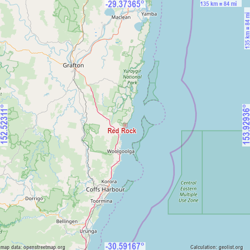
Red Rock GPS coordinates[2]
29° 59' 4.308" South, 153° 13' 34.428" East
| Map corner | latitude | longitude |
|---|---|---|
| Upper-left | -29.37365°, | 152.52311° |
| Center: | -29.98453°, | 153.22623° |
| Lower-right: | -30.59167°, | 153.92936° |
| Map W x H: | 135.4×135.4 km | = 84.1×84.1mi |
| max Lat: | -10.58257° ⇑27.6% North |
| Red Rock: | -29.98453° |
| min Lat: | ⇓72.4% South -43.31423° |
| min Long | Red Rock | max Long |
| 113.53327° | 153.22623° | 153.61246° |
| W 97%⇐ | ⇒3% E |
Elevation
Elevation of Red Rock is 8 m = 26 ft, and this is 114 m = 374 ft below average elevation for this country.
| Max E: |
1715 m = 5627 ft | 91.8% |
| Avg. | 122 m = 400 ft | |
| Red Rock | 8 m = 26 ft | |
Min E: |
-2 m = -7 ft | 8.2% |
See also: Australia elevation on elevation.city.
Geographical zone
Red Rock is located in South temperate zone (between Tropic of Capricorn and the Antarctic Circle). Distance of this Southern Tropic circle is 728 km =452.4 mi to North.| Distance of | km | miles | from Red Rock |
|---|---|---|---|
| Equator | 3334 | 2071.7 | to North |
| Tropic Capricorn | 728 | 452.4 | to North |
| Antarctic Circle | 4067.2 | 2527.2 | to South |
| South Pole | 6673.1 | 4146.5 | to South |


Nearby cities:
15 places around Red Rock: (largest is in red/bold)
• Arrawarra
9.1 km =5.7 mi,  202°
202°
• Arrawarra Headland
9.9 km =6.2 mi, 196°
• Bucca
23 km =14.3 mi,  213°
213°
• Coramba
33.3 km =20.7 mi,  218°
218°
• Corindi
5.4 km =3.4 mi, 212°
• Corindi Beach
5.3 km =3.3 mi,  227°
227°
• Emerald Beach
20.4 km =12.7 mi,  192°
192°
• Glenreagh
25 km =15.5 mi,  252°
252°
• Korora
31 km =19.3 mi, 200°
• Moonee Beach
25.6 km =15.9 mi, 195°
• Mullaway
11 km =6.8 mi, 195°
• Nana Glen
26.1 km =16.2 mi, 230°
• Sandy Beach
18.3 km =11.4 mi, 190°
• Sapphire Beach
28.2 km =17.5 mi, 197°
• Woolgoolga
14.2 km =8.8 mi, 189°
Sources, notices
• [Note1] Compared only with cities in Australia existing in our database
• [Src1] Map data: © OpenStreetMap contributors (CC-BY-SA)
• [Src2] Other city data from geonames.org with taken over terms of usage.
• [Src3] Geographical zone / Annual Mean Temperature by Robert A. Rohde @ Wikipedia
