Caniaba geodata
Caniaba (New South Wales) is a section of populated place; located in Australia in Australia/Sydney (GMT+11) time zone. With population of 666 people, there are 4391 cities with bigger population in this country. Compared to other cities in Australia, 73.3% of cities are located further ↓South; 96.8% of cities are located further ←West and 50.2% of cities have lower elevation than Caniaba. Note1


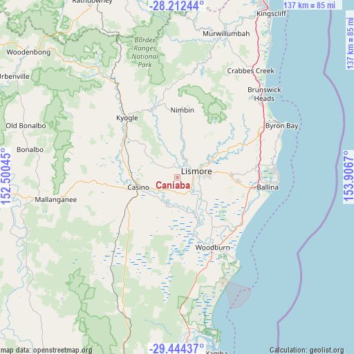
Caniaba GPS coordinates[2]
28° 49' 48.828" South, 153° 12' 12.852" East
| Map corner | latitude | longitude |
|---|---|---|
| Upper-left | -28.21244°, | 152.50045° |
| Center: | -28.83023°, | 153.20357° |
| Lower-right: | -29.44437°, | 153.9067° |
| Map W x H: | 137×137 km | = 85.1×85.1mi |
| max Lat: | -10.58257° ⇑26.7% North |
| Caniaba: | -28.83023° |
| min Lat: | ⇓73.3% South -43.31423° |
| min Long | Caniaba | max Long |
| 113.53327° | 153.20357° | 153.61246° |
| W 96.8%⇐ | ⇒3.2% E |
Elevation
Elevation of Caniaba is 46 m = 151 ft, and this is 76 m = 249 ft below average elevation for this country.
| Max E: |
1715 m = 5627 ft | 49.8% |
| Avg. | 122 m = 400 ft | |
| Caniaba | 46 m = 151 ft | |
Min E: |
-2 m = -7 ft | 50.2% |
See also: Australia elevation on elevation.city.
Geographical zone
Caniaba is located in South temperate zone (between Tropic of Capricorn and the Antarctic Circle). Distance of this Southern Tropic circle is 599.7 km =372.6 mi to North.| Distance of | km | miles | from Caniaba |
|---|---|---|---|
| Equator | 3205.6 | 1991.9 | to North |
| Tropic Capricorn | 599.7 | 372.6 | to North |
| Antarctic Circle | 4195.6 | 2607 | to South |
| South Pole | 6801.4 | 4226.2 | to South |


Nearby cities:
15 places around Caniaba: (largest is in red/bold)
• Casino
15.5 km =9.6 mi,  258°
258°
• Clunes
22.7 km =14.1 mi,  60°
60°
• Coraki
19.7 km =12.2 mi,  156°
156°
• Dunoon
19.6 km =12.2 mi,  34°
34°
• East Lismore
8.3 km =5.2 mi,  86°
86°
• Girards Hill
7.4 km =4.6 mi,  78°
78°
• Goonellabah
11.1 km =6.9 mi, 82°
• Lismore
7.4 km =4.6 mi, 75°
• Lismore Heights
10 km =6.2 mi,  71°
71°
• McLeans Ridges
17.8 km =11.1 mi, 79°
• Modanville
15.9 km =9.9 mi,  36°
36°
• North Casino
13.7 km =8.5 mi,  283°
283°
• North Lismore
8.8 km =5.5 mi, 58°
• South Lismore
5.4 km =3.4 mi, 73°
• Wollongbar
18.9 km =11.7 mi, 85°
Sources, notices
• [Note1] Compared only with cities in Australia existing in our database
• [Src1] Map data: © OpenStreetMap contributors (CC-BY-SA)
• [Src2] Other city data from geonames.org with taken over terms of usage.
• [Src3] Geographical zone / Annual Mean Temperature by Robert A. Rohde @ Wikipedia
