Wollongbar geodata
Wollongbar (New South Wales) is a populated place; located in Australia in Australia/Sydney (GMT+11) time zone. With population of 2,770 people, there are 2400 cities with bigger population in this country. Compared to other cities in Australia, 73.5% of cities are located further ↓South; 98.6% of cities are located further ←West and 73.2% of cities have lower elevation than Wollongbar. Note1


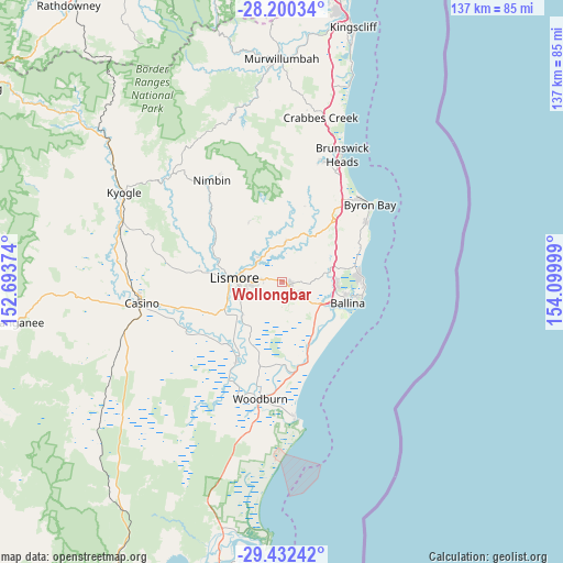
Wollongbar GPS coordinates[2]
28° 49' 5.52" South, 153° 23' 48.696" East
| Map corner | latitude | longitude |
|---|---|---|
| Upper-left | -28.20034°, | 152.69374° |
| Center: | -28.8182°, | 153.39686° |
| Lower-right: | -29.43242°, | 154.09999° |
| Map W x H: | 137×137 km | = 85.1×85.1mi |
| max Lat: | -10.58257° ⇑26.5% North |
| Wollongbar: | -28.8182° |
| min Lat: | ⇓73.5% South -43.31423° |
| min Long | Wollongbar | max Long |
| 113.53327° | 153.39686° | 153.61246° |
| W 98.6%⇐ | ⇒1.4% E |
Elevation
Elevation of Wollongbar is 118 m = 387 ft, and this is 4 m = 13 ft below average elevation for this country.
| Max E: |
1715 m = 5627 ft | 26.8% |
| Avg. | 122 m = 400 ft | |
| Wollongbar | 118 m = 387 ft | |
Min E: |
-2 m = -7 ft | 73.2% |
See also: Australia elevation on elevation.city.
Geographical zone
Wollongbar is located in South temperate zone (between Tropic of Capricorn and the Antarctic Circle). Distance of this Southern Tropic circle is 598.4 km =371.8 mi to North.| Distance of | km | miles | from Wollongbar |
|---|---|---|---|
| Equator | 3204.3 | 1991.1 | to North |
| Tropic Capricorn | 598.4 | 371.8 | to North |
| Antarctic Circle | 4196.9 | 2607.8 | to South |
| South Pole | 6802.8 | 4227.1 | to South |


Nearby cities:
15 places around Wollongbar: (largest is in red/bold)
• Alstonville
5 km =3.1 mi,  121°
121°
• Clunes
9.7 km =6 mi,  6°
6°
• Cumbalum
12.8 km =8 mi,  92°
92°
• East Lismore
10.6 km =6.6 mi,  265°
265°
• Girards Hill
11.6 km =7.2 mi, 270°
• Goonellabah
7.8 km =4.8 mi, 271°
• Lismore
11.7 km =7.3 mi, 272°
• Lismore Heights
9.6 km =6 mi,  281°
281°
• McLeans Ridges
2.4 km =1.5 mi,  326°
326°
• Modanville
14.8 km =9.2 mi,  320°
320°
• North Lismore
11.8 km =7.3 mi,  286°
286°
• South Lismore
13.7 km =8.5 mi, 270°
• Tintenbar
12.4 km =7.7 mi,  79°
79°
• Wardell
16.1 km =10 mi,  156°
156°
• West Ballina
14.1 km =8.8 mi,  110°
110°
Sources, notices
• [Note1] Compared only with cities in Australia existing in our database
• [Src1] Map data: © OpenStreetMap contributors (CC-BY-SA)
• [Src2] Other city data from geonames.org with taken over terms of usage.
• [Src3] Geographical zone / Annual Mean Temperature by Robert A. Rohde @ Wikipedia
