Goonellabah geodata
Goonellabah (New South Wales) is a populated place; located in Australia in Australia/Sydney (GMT+11) time zone. With population of 12,781 people, there are 366 cities with bigger population in this country. Compared to other cities in Australia, 73.5% of cities are located further ↓South; 97.8% of cities are located further ←West and 79.3% of cities have lower elevation than Goonellabah. Note1


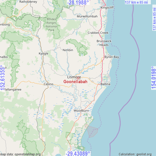
Goonellabah GPS coordinates[2]
28° 49' 0.012" South, 153° 19' 0.012" East
| Map corner | latitude | longitude |
|---|---|---|
| Upper-left | -28.1988°, | 152.61355° |
| Center: | -28.81667°, | 153.31667° |
| Lower-right: | -29.43089°, | 154.0198° |
| Map W x H: | 137×137 km | = 85.1×85.1mi |
| max Lat: | -10.58257° ⇑26.5% North |
| Goonellabah: | -28.81667° |
| min Lat: | ⇓73.5% South -43.31423° |
| min Long | Goonellabah | max Long |
| 113.53327° | 153.31667° | 153.61246° |
| W 97.8%⇐ | ⇒2.2% E |
Elevation
Elevation of Goonellabah is 171 m = 561 ft, and this is 49 m = 161 ft above average elevation for this country.
| Max E: |
1715 m = 5627 ft | 20.7% |
| Goonellabah | 171 m 561 ft | |
| Avg. | 122 m = 400 ft | |
Min E: |
-2 m = -7 ft | 79.3% |
See also: Australia elevation on elevation.city.
Geographical zone
Goonellabah is located in South temperate zone (between Tropic of Capricorn and the Antarctic Circle). Distance of this Southern Tropic circle is 598.2 km =371.7 mi to North.| Distance of | km | miles | from Goonellabah |
|---|---|---|---|
| Equator | 3204.1 | 1990.9 | to North |
| Tropic Capricorn | 598.2 | 371.7 | to North |
| Antarctic Circle | 4197.1 | 2608 | to South |
| South Pole | 6802.9 | 4227.1 | to South |


Nearby cities:
15 places around Goonellabah: (largest is in red/bold)
• Alstonville
12.4 km =7.7 mi,  103°
103°
• Caniaba
11.1 km =6.9 mi,  262°
262°
• Clunes
13 km =8.1 mi,  42°
42°
• Coraki
19.8 km =12.3 mi,  189°
189°
• Dunoon
14.7 km =9.1 mi,  0°
0°
• East Lismore
2.9 km =1.8 mi,  249°
249°
• Girards Hill
3.8 km =2.4 mi,  269°
269°
• Lismore
3.9 km =2.4 mi,  275°
275°
• Lismore Heights
2.3 km =1.4 mi,  317°
317°
• McLeans Ridges
6.8 km =4.2 mi,  74°
74°
• Modanville
11.4 km =7.1 mi,  352°
352°
• North Lismore
4.7 km =2.9 mi,  311°
311°
• South Lismore
5.9 km =3.7 mi, 270°
• Tintenbar
20.1 km =12.5 mi,  84°
84°
• Wollongbar
7.8 km =4.8 mi,  91°
91°
Sources, notices
• [Note1] Compared only with cities in Australia existing in our database
• [Src1] Map data: © OpenStreetMap contributors (CC-BY-SA)
• [Src2] Other city data from geonames.org with taken over terms of usage.
• [Src3] Geographical zone / Annual Mean Temperature by Robert A. Rohde @ Wikipedia
