Dunoon geodata
Dunoon (New South Wales) is a populated place; located in Australia in Australia/Sydney (GMT+11) time zone. With population of 672 people, there are 4378 cities with bigger population in this country. Compared to other cities in Australia, 74.2% of cities are located further ↓South; 97.8% of cities are located further ←West and 83.2% of cities have lower elevation than Dunoon. Note1


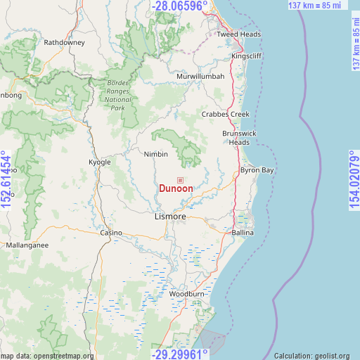
Dunoon GPS coordinates[2]
28° 41' 4.56" South, 153° 19' 3.576" East
| Map corner | latitude | longitude |
|---|---|---|
| Upper-left | -28.06596°, | 152.61454° |
| Center: | -28.6846°, | 153.31766° |
| Lower-right: | -29.29961°, | 154.02079° |
| Map W x H: | 137.2×137.2 km | = 85.3×85.3mi |
| max Lat: | -10.58257° ⇑25.8% North |
| Dunoon: | -28.6846° |
| min Lat: | ⇓74.2% South -43.31423° |
| min Long | Dunoon | max Long |
| 113.53327° | 153.31766° | 153.61246° |
| W 97.8%⇐ | ⇒2.2% E |
Elevation
Elevation of Dunoon is 220 m = 722 ft, and this is 98 m = 322 ft above average elevation for this country.
| Max E: |
1715 m = 5627 ft | 16.8% |
| Dunoon | 220 m 722 ft | |
| Avg. | 122 m = 400 ft | |
Min E: |
-2 m = -7 ft | 83.2% |
See also: Australia elevation on elevation.city.
Geographical zone
Dunoon is located in South temperate zone (between Tropic of Capricorn and the Antarctic Circle). Distance of this Southern Tropic circle is 583.5 km =362.6 mi to North.| Distance of | km | miles | from Dunoon |
|---|---|---|---|
| Equator | 3189.4 | 1981.8 | to North |
| Tropic Capricorn | 583.5 | 362.6 | to North |
| Antarctic Circle | 4211.7 | 2617 | to South |
| South Pole | 6817.6 | 4236.3 | to South |


Nearby cities:
15 places around Dunoon: (largest is in red/bold)
• Caniaba
19.6 km =12.2 mi,  214°
214°
• Clunes
10.2 km =6.3 mi,  120°
120°
• East Lismore
16 km =9.9 mi,  190°
190°
• Federal
13.6 km =8.5 mi,  72°
72°
• Girards Hill
15.2 km =9.4 mi, 194°
• Goonellabah
14.7 km =9.1 mi,  180°
180°
• Lismore
14.9 km =9.3 mi,  195°
195°
• Lismore Heights
13.1 km =8.1 mi, 187°
• McLeans Ridges
14.3 km =8.9 mi,  153°
153°
• Modanville
3.8 km =2.4 mi, 205°
• Mullumbimby Creek
19.1 km =11.9 mi,  36°
36°
• Nimbin
13.5 km =8.4 mi,  317°
317°
• North Lismore
12.1 km =7.5 mi, 197°
• South Lismore
15.8 km =9.8 mi, 202°
• Wollongbar
16.7 km =10.4 mi, 152°
Sources, notices
• [Note1] Compared only with cities in Australia existing in our database
• [Src1] Map data: © OpenStreetMap contributors (CC-BY-SA)
• [Src2] Other city data from geonames.org with taken over terms of usage.
• [Src3] Geographical zone / Annual Mean Temperature by Robert A. Rohde @ Wikipedia
