Ashby geodata
Ashby (Western Australia) is a section of populated place; located in Australia in Australia/Perth (GMT+8) time zone. With population of 2,548 people, there are 2534 cities with bigger population in this country. Compared to other cities in Australia, 68.8% of cities are located further ↓South; 96.2% of cities are located further →East and 52% of cities have lower elevation than Ashby. Note1


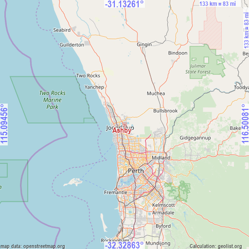
Ashby GPS coordinates[2]
31° 43' 57.18" South, 115° 47' 51.648" East
| Map corner | latitude | longitude |
|---|---|---|
| Upper-left | -31.13261°, | 115.09456° |
| Center: | -31.73255°, | 115.79768° |
| Lower-right: | -32.32863°, | 116.50081° |
| Map W x H: | 133×133 km | = 82.6×82.6mi |
| max Lat: | -10.58257° ⇑31.2% North |
| Ashby: | -31.73255° |
| min Lat: | ⇓68.8% South -43.31423° |
| min Long | Ashby | max Long |
| 113.53327° | 115.79768° | 153.61246° |
| W 3.8%⇐ | ⇒96.2% E |
Elevation
Elevation of Ashby is 48 m = 157 ft, and this is 74 m = 243 ft below average elevation for this country.
| Max E: |
1715 m = 5627 ft | 48% |
| Avg. | 122 m = 400 ft | |
| Ashby | 48 m = 157 ft | |
Min E: |
-2 m = -7 ft | 52% |
See also: Australia elevation on elevation.city.
Geographical zone
Ashby is located in South temperate zone (between Tropic of Capricorn and the Antarctic Circle). Distance of this Southern Tropic circle is 922.4 km =573.2 mi to North.| Distance of | km | miles | from Ashby |
|---|---|---|---|
| Equator | 3528.3 | 2192.4 | to North |
| Tropic Capricorn | 922.4 | 573.2 | to North |
| Antarctic Circle | 3872.8 | 2406.4 | to South |
| South Pole | 6478.7 | 4025.7 | to South |


Nearby cities:
15 places around Ashby: (largest is in red/bold)
• Banksia Grove
4.1 km =2.5 mi,  9°
9°
• Beldon
5.7 km =3.5 mi,  215°
215°
• Carramar
5.3 km =3.3 mi,  332°
332°
• Connolly
4.8 km =3 mi,  248°
248°
• Currambine
4.7 km =2.9 mi,  269°
269°
• Edgewater
3.9 km =2.4 mi,  201°
201°
• Heathridge
4.9 km =3 mi,  227°
227°
• Hocking
4.6 km =2.9 mi,  154°
154°
• Joondalup
3.1 km =1.9 mi,  244°
244°
• Kinross
5.8 km =3.6 mi,  285°
285°
• Mariginiup
4.9 km =3 mi,  60°
60°
• Pearsall
5.7 km =3.5 mi,  160°
160°
• Sinagra
1.4 km =0.9 mi,  143°
143°
• Tapping
1.5 km =0.9 mi,  352°
352°
• Wanneroo
2 km =1.2 mi,  173°
173°
Sources, notices
• [Note1] Compared only with cities in Australia existing in our database
• [Src1] Map data: © OpenStreetMap contributors (CC-BY-SA)
• [Src2] Other city data from geonames.org with taken over terms of usage.
• [Src3] Geographical zone / Annual Mean Temperature by Robert A. Rohde @ Wikipedia
