Beldon geodata
Beldon (Western Australia) is a section of populated place; located in Australia in Australia/Perth (GMT+8) time zone. With population of 3,859 people, there are 1844 cities with bigger population in this country. Compared to other cities in Australia, 68.4% of cities are located further ↓South; 97.1% of cities are located further →East and 50.4% of cities have higher elevation than Beldon. Note1


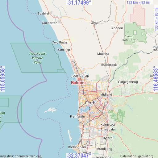
Beldon GPS coordinates[2]
31° 46' 28.776" South, 115° 45' 45.72" East
| Map corner | latitude | longitude |
|---|---|---|
| Upper-left | -31.17499°, | 115.05958° |
| Center: | -31.77466°, | 115.7627° |
| Lower-right: | -32.37047°, | 116.46583° |
| Map W x H: | 132.9×132.9 km | = 82.6×82.6mi |
| max Lat: | -10.58257° ⇑31.6% North |
| Beldon: | -31.77466° |
| min Lat: | ⇓68.4% South -43.31423° |
| min Long | Beldon | max Long |
| 113.53327° | 115.7627° | 153.61246° |
| W 2.9%⇐ | ⇒97.1% E |
Elevation
Elevation of Beldon is 45 m = 148 ft, and this is 77 m = 253 ft below average elevation for this country.
| Max E: |
1715 m = 5627 ft | 50.4% |
| Avg. | 122 m = 400 ft | |
| Beldon | 45 m = 148 ft | |
Min E: |
-2 m = -7 ft | 49.6% |
See also: Australia elevation on elevation.city.
Geographical zone
Beldon is located in South temperate zone (between Tropic of Capricorn and the Antarctic Circle). Distance of this Southern Tropic circle is 927.1 km =576.1 mi to North.| Distance of | km | miles | from Beldon |
|---|---|---|---|
| Equator | 3533 | 2195.3 | to North |
| Tropic Capricorn | 927.1 | 576.1 | to North |
| Antarctic Circle | 3868.2 | 2403.6 | to South |
| South Pole | 6474.1 | 4022.8 | to South |


Nearby cities:
15 places around Beldon: (largest is in red/bold)
• Connolly
3.1 km =1.9 mi,  338°
338°
• Craigie
1.6 km =1 mi,  154°
154°
• Currambine
4.8 km =3 mi, 342°
• Edgewater
2.1 km =1.3 mi,  61°
61°
• Heathridge
1.4 km =0.9 mi,  345°
345°
• Hillarys
4.2 km =2.6 mi,  210°
210°
• Hocking
5.3 km =3.3 mi,  84°
84°
• Joondalup
3.4 km =2.1 mi,  9°
9°
• Kallaroo
2 km =1.2 mi, 206°
• Mullaloo
2.5 km =1.6 mi,  258°
258°
• Ocean Reef
3.1 km =1.9 mi,  305°
305°
• Padbury
3.6 km =2.2 mi,  170°
170°
• Pearsall
5.3 km =3.3 mi,  97°
97°
• Wanneroo
4.5 km =2.8 mi,  52°
52°
• Woodvale
3.6 km =2.2 mi,  116°
116°
Sources, notices
• [Note1] Compared only with cities in Australia existing in our database
• [Src1] Map data: © OpenStreetMap contributors (CC-BY-SA)
• [Src2] Other city data from geonames.org with taken over terms of usage.
• [Src3] Geographical zone / Annual Mean Temperature by Robert A. Rohde @ Wikipedia
