Oakdale geodata
Oakdale (New South Wales) is a populated place; located in Australia in Australia/Sydney (GMT+11) time zone. With population of 1,813 people, there are 3040 cities with bigger population in this country. Compared to other cities in Australia, 60.5% of cities are located further ↑North; 58.8% of cities are located further ←West and 91% of cities have lower elevation than Oakdale. Note1


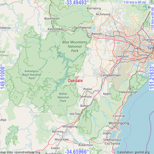
Oakdale GPS coordinates[2]
34° 4' 45.48" South, 150° 30' 47.52" East
| Map corner | latitude | longitude |
|---|---|---|
| Upper-left | -33.49493°, | 149.81008° |
| Center: | -34.0793°, | 150.5132° |
| Lower-right: | -34.65966°, | 151.21633° |
| Map W x H: | 129.5×129.5 km | = 80.5×80.5mi |
| max Lat: | -10.58257° ⇑60.5% North |
| Oakdale: | -34.0793° |
| min Lat: | ⇓39.5% South -43.31423° |
| min Long | Oakdale | max Long |
| 113.53327° | 150.5132° | 153.61246° |
| W 58.8%⇐ | ⇒41.2% E |
Elevation
Elevation of Oakdale is 414 m = 1358 ft, and this is 292 m = 958 ft above average elevation for this country.
| Max E: |
1715 m = 5627 ft | 9% |
| Oakdale | 414 m 1358 ft | |
| Avg. | 122 m = 400 ft | |
Min E: |
-2 m = -7 ft | 91% |
See also: Australia elevation on elevation.city.
Geographical zone
Oakdale is located in South temperate zone (between Tropic of Capricorn and the Antarctic Circle). Distance of this Southern Tropic circle is 1183.3 km =735.3 mi to North.| Distance of | km | miles | from Oakdale |
|---|---|---|---|
| Equator | 3789.3 | 2354.6 | to North |
| Tropic Capricorn | 1183.3 | 735.3 | to North |
| Antarctic Circle | 3611.9 | 2244.3 | to South |
| South Pole | 6217.8 | 3863.6 | to South |


Nearby cities:
15 places around Oakdale: (largest is in red/bold)
• Belimbla Park
2.5 km =1.6 mi,  102°
102°
• Camden
17.1 km =10.6 mi,  80°
80°
• Camden South
16.7 km =10.4 mi,  91°
91°
• Cobbitty
16.8 km =10.4 mi,  65°
65°
• Ellis Lane
16.1 km =10 mi, 71°
• Grasmere
14.4 km =8.9 mi, 78°
• Mount Hunter
11.5 km =7.1 mi, 85°
• Orangeville
9.8 km =6.1 mi,  56°
56°
• Picton
13.6 km =8.5 mi,  138°
138°
• Razorback
15.2 km =9.4 mi,  122°
122°
• Tahmoor
17.6 km =10.9 mi,  154°
154°
• The Oaks
5.2 km =3.2 mi, 90°
• Theresa Park
13.8 km =8.6 mi,  54°
54°
• Thirlmere
14.8 km =9.2 mi,  160°
160°
• Werombi
12.5 km =7.8 mi,  31°
31°
Sources, notices
• [Note1] Compared only with cities in Australia existing in our database
• [Src1] Map data: © OpenStreetMap contributors (CC-BY-SA)
• [Src2] Other city data from geonames.org with taken over terms of usage.
• [Src3] Geographical zone / Annual Mean Temperature by Robert A. Rohde @ Wikipedia
