Belimbla Park geodata
Belimbla Park (New South Wales) is a section of populated place; located in Australia in Australia/Sydney (GMT+11) time zone. With population of 569 people, there are 4649 cities with bigger population in this country. Compared to other cities in Australia, 60.6% of cities are located further ↑North; 59.1% of cities are located further ←West and 89.3% of cities have lower elevation than Belimbla Park. Note1


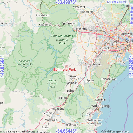
Belimbla Park GPS coordinates[2]
34° 5' 2.76" South, 150° 32' 23.136" East
| Map corner | latitude | longitude |
|---|---|---|
| Upper-left | -33.49976°, | 149.83664° |
| Center: | -34.0841°, | 150.53976° |
| Lower-right: | -34.66443°, | 151.24289° |
| Map W x H: | 129.5×129.5 km | = 80.5×80.5mi |
| max Lat: | -10.58257° ⇑60.6% North |
| Belimbla Park: | -34.0841° |
| min Lat: | ⇓39.4% South -43.31423° |
| min Long | Belimbla Park | max Long |
| 113.53327° | 150.53976° | 153.61246° |
| W 59.1%⇐ | ⇒40.9% E |
Elevation
Elevation of Belimbla Park is 354 m = 1161 ft, and this is 232 m = 761 ft above average elevation for this country.
| Max E: |
1715 m = 5627 ft | 10.7% |
| Belimbla Park | 354 m 1161 ft | |
| Avg. | 122 m = 400 ft | |
Min E: |
-2 m = -7 ft | 89.3% |
See also: Australia elevation on elevation.city.
Geographical zone
Belimbla Park is located in South temperate zone (between Tropic of Capricorn and the Antarctic Circle). Distance of this Southern Tropic circle is 1183.9 km =735.6 mi to North.| Distance of | km | miles | from Belimbla Park |
|---|---|---|---|
| Equator | 3789.8 | 2354.9 | to North |
| Tropic Capricorn | 1183.9 | 735.6 | to North |
| Antarctic Circle | 3611.4 | 2244 | to South |
| South Pole | 6217.3 | 3863.2 | to South |


Nearby cities:
15 places around Belimbla Park: (largest is in red/bold)
• Camden
14.8 km =9.2 mi,  76°
76°
• Camden South
14.3 km =8.9 mi,  89°
89°
• Cobbitty
14.9 km =9.3 mi,  59°
59°
• Ellis Lane
14 km =8.7 mi,  65°
65°
• Grasmere
12.1 km =7.5 mi, 73°
• Mount Hunter
9.1 km =5.7 mi, 81°
• Oakdale
2.5 km =1.6 mi,  282°
282°
• Orangeville
8.2 km =5.1 mi,  44°
44°
• Picton
11.6 km =7.2 mi,  145°
145°
• Razorback
12.9 km =8 mi,  126°
126°
• Spring Farm
15.9 km =9.9 mi, 83°
• The Oaks
2.8 km =1.7 mi, 80°
• Theresa Park
12.3 km =7.6 mi,  45°
45°
• Thirlmere
13.6 km =8.5 mi,  169°
169°
• Werombi
11.9 km =7.4 mi,  19°
19°
Sources, notices
• [Note1] Compared only with cities in Australia existing in our database
• [Src1] Map data: © OpenStreetMap contributors (CC-BY-SA)
• [Src2] Other city data from geonames.org with taken over terms of usage.
• [Src3] Geographical zone / Annual Mean Temperature by Robert A. Rohde @ Wikipedia
