Kambah geodata
Kambah (ACT) is a section of populated place; located in Australia in Australia/Sydney (GMT+11) time zone. With population of 14,539 people, there are 292 cities with bigger population in this country. Compared to other cities in Australia, 76.5% of cities are located further ↑North; 53.2% of cities are located further ←West and 95.6% of cities have lower elevation than Kambah. Note1


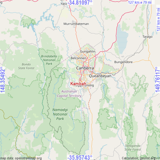
Kambah GPS coordinates[2]
35° 23' 10.464" South, 149° 3' 28.944" East
| Map corner | latitude | longitude |
|---|---|---|
| Upper-left | -34.81097°, | 148.35492° |
| Center: | -35.38624°, | 149.05804° |
| Lower-right: | -35.95743°, | 149.76117° |
| Map W x H: | 127.5×127.5 km | = 79.2×79.2mi |
| max Lat: | -10.58257° ⇑76.5% North |
| Kambah: | -35.38624° |
| min Lat: | ⇓23.5% South -43.31423° |
| min Long | Kambah | max Long |
| 113.53327° | 149.05804° | 153.61246° |
| W 53.2%⇐ | ⇒46.8% E |
Elevation
Elevation of Kambah is 596 m = 1955 ft, and this is 474 m = 1555 ft above average elevation for this country.
| Max E: |
1715 m = 5627 ft | 4.4% |
| Kambah | 596 m 1955 ft | |
| Avg. | 122 m = 400 ft | |
Min E: |
-2 m = -7 ft | 95.6% |
See also: Australia elevation on elevation.city.
Geographical zone
Kambah is located in South temperate zone (between Tropic of Capricorn and the Antarctic Circle). Distance of this Southern Tropic circle is 1328.7 km =825.6 mi to North.| Distance of | km | miles | from Kambah |
|---|---|---|---|
| Equator | 3934.6 | 2444.8 | to North |
| Tropic Capricorn | 1328.7 | 825.6 | to North |
| Antarctic Circle | 3466.6 | 2154 | to South |
| South Pole | 6072.5 | 3773.3 | to South |


Nearby cities:
15 places around Kambah: (largest is in red/bold)
• Chapman
3.8 km =2.4 mi,  330°
330°
• Chifley
4 km =2.5 mi,  25°
25°
• Farrer
4.4 km =2.7 mi,  76°
76°
• Fisher
2.8 km =1.7 mi,  358°
358°
• Greenway
3.6 km =2.2 mi,  167°
167°
• Mawson
4.5 km =2.8 mi,  55°
55°
• Monash
4.4 km =2.7 mi,  138°
138°
• Oxley
3.2 km =2 mi, 144°
• Pearce
3.5 km =2.2 mi,  40°
40°
• Phillip
5 km =3.1 mi, 37°
• Rivett
4.7 km =2.9 mi,  337°
337°
• Stirling
4.1 km =2.5 mi,  348°
348°
• Torrens
3.1 km =1.9 mi, 59°
• Wanniassa
3.2 km =2 mi,  113°
113°
• Waramanga
3.7 km =2.3 mi,  5°
5°
Sources, notices
• [Note1] Compared only with cities in Australia existing in our database
• [Src1] Map data: © OpenStreetMap contributors (CC-BY-SA)
• [Src2] Other city data from geonames.org with taken over terms of usage.
• [Src3] Geographical zone / Annual Mean Temperature by Robert A. Rohde @ Wikipedia
