Stirling geodata
Stirling (ACT) is a section of populated place; located in Australia in Australia/Sydney (GMT+11) time zone. With population of 2,117 people, there are 2814 cities with bigger population in this country. Compared to other cities in Australia, 76% of cities are located further ↑North; 53.1% of cities are located further ←West and 95.9% of cities have lower elevation than Stirling. Note1


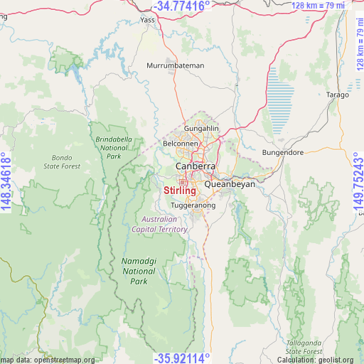
Stirling GPS coordinates[2]
35° 20' 58.884" South, 149° 2' 57.48" East
| Map corner | latitude | longitude |
|---|---|---|
| Upper-left | -34.77416°, | 148.34618° |
| Center: | -35.34969°, | 149.0493° |
| Lower-right: | -35.92114°, | 149.75243° |
| Map W x H: | 127.5×127.5 km | = 79.2×79.2mi |
| max Lat: | -10.58257° ⇑76% North |
| Stirling: | -35.34969° |
| min Lat: | ⇓24% South -43.31423° |
| min Long | Stirling | max Long |
| 113.53327° | 149.0493° | 153.61246° |
| W 53.1%⇐ | ⇒46.9% E |
Elevation
Elevation of Stirling is 601 m = 1972 ft, and this is 479 m = 1572 ft above average elevation for this country.
| Max E: |
1715 m = 5627 ft | 4.1% |
| Stirling | 601 m 1972 ft | |
| Avg. | 122 m = 400 ft | |
Min E: |
-2 m = -7 ft | 95.9% |
See also: Australia elevation on elevation.city.
Geographical zone
Stirling is located in South temperate zone (between Tropic of Capricorn and the Antarctic Circle). Distance of this Southern Tropic circle is 1324.6 km =823.1 mi to North.| Distance of | km | miles | from Stirling |
|---|---|---|---|
| Equator | 3930.5 | 2442.3 | to North |
| Tropic Capricorn | 1324.6 | 823.1 | to North |
| Antarctic Circle | 3470.7 | 2156.6 | to South |
| South Pole | 6076.5 | 3775.8 | to South |


Nearby cities:
15 places around Stirling: (largest is in red/bold)
• Chapman
1.3 km =0.8 mi,  236°
236°
• Chifley
2.5 km =1.6 mi,  99°
99°
• Coombs
3.8 km =2.4 mi,  346°
346°
• Curtin
3.8 km =2.4 mi,  42°
42°
• Duffy
2.3 km =1.4 mi,  316°
316°
• Fisher
1.5 km =0.9 mi,  151°
151°
• Holder
1.7 km =1.1 mi, 350°
• Kambah
4.1 km =2.5 mi,  168°
168°
• Lyons
2.5 km =1.6 mi,  65°
65°
• Pearce
3.4 km =2.1 mi,  114°
114°
• Phillip
3.8 km =2.4 mi,  91°
91°
• Rivett
1.1 km =0.7 mi,  285°
285°
• Waramanga
1.2 km =0.7 mi, 107°
• Weston
1.8 km =1.1 mi,  30°
30°
• Wright
3.3 km =2.1 mi,  336°
336°
Sources, notices
• [Note1] Compared only with cities in Australia existing in our database
• [Src1] Map data: © OpenStreetMap contributors (CC-BY-SA)
• [Src2] Other city data from geonames.org with taken over terms of usage.
• [Src3] Geographical zone / Annual Mean Temperature by Robert A. Rohde @ Wikipedia
