Chapman geodata
Chapman (ACT) is a section of populated place; located in Australia in Australia/Sydney (GMT+11) time zone. With population of 2,573 people, there are 2520 cities with bigger population in this country. Compared to other cities in Australia, 76.2% of cities are located further ↑North; 52.9% of cities are located further ←West and 97.5% of cities have lower elevation than Chapman. Note1


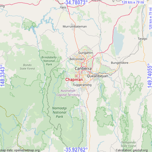
Chapman GPS coordinates[2]
35° 21' 22.356" South, 149° 2' 14.712" East
| Map corner | latitude | longitude |
|---|---|---|
| Upper-left | -34.78073°, | 148.3343° |
| Center: | -35.35621°, | 149.03742° |
| Lower-right: | -35.92762°, | 149.74055° |
| Map W x H: | 127.5×127.5 km | = 79.2×79.2mi |
| max Lat: | -10.58257° ⇑76.2% North |
| Chapman: | -35.35621° |
| min Lat: | ⇓23.8% South -43.31423° |
| min Long | Chapman | max Long |
| 113.53327° | 149.03742° | 153.61246° |
| W 52.9%⇐ | ⇒47.1% E |
Elevation
Elevation of Chapman is 645 m = 2116 ft, and this is 523 m = 1716 ft above average elevation for this country.
| Max E: |
1715 m = 5627 ft | 2.5% |
| Chapman | 645 m 2116 ft | |
| Avg. | 122 m = 400 ft | |
Min E: |
-2 m = -7 ft | 97.5% |
See also: Australia elevation on elevation.city.
Geographical zone
Chapman is located in South temperate zone (between Tropic of Capricorn and the Antarctic Circle). Distance of this Southern Tropic circle is 1325.3 km =823.5 mi to North.| Distance of | km | miles | from Chapman |
|---|---|---|---|
| Equator | 3931.2 | 2442.7 | to North |
| Tropic Capricorn | 1325.3 | 823.5 | to North |
| Antarctic Circle | 3469.9 | 2156.1 | to South |
| South Pole | 6075.8 | 3775.3 | to South |


Nearby cities:
15 places around Chapman: (largest is in red/bold)
• Chifley
3.6 km =2.2 mi,  85°
85°
• Coombs
4.4 km =2.7 mi,  2°
2°
• Duffy
2.5 km =1.6 mi,  348°
348°
• Fisher
1.9 km =1.2 mi,  107°
107°
• Holder
2.6 km =1.6 mi,  18°
18°
• Kambah
3.8 km =2.4 mi,  150°
150°
• Lyons
3.7 km =2.3 mi,  62°
62°
• Pearce
4.2 km =2.6 mi,  99°
99°
• Phillip
4.9 km =3 mi,  82°
82°
• Rivett
1 km =0.6 mi, 2°
• Stirling
1.3 km =0.8 mi, 56°
• Torrens
4.9 km =3 mi, 111°
• Waramanga
2.3 km =1.4 mi, 80°
• Weston
3 km =1.9 mi,  41°
41°
• Wright
3.8 km =2.4 mi,  356°
356°
Sources, notices
• [Note1] Compared only with cities in Australia existing in our database
• [Src1] Map data: © OpenStreetMap contributors (CC-BY-SA)
• [Src2] Other city data from geonames.org with taken over terms of usage.
• [Src3] Geographical zone / Annual Mean Temperature by Robert A. Rohde @ Wikipedia
