Argyle geodata
Argyle (Western Australia) is a section of populated place; located in Australia in Australia/Perth (GMT+8) time zone. With population of 525 people, there are 4798 cities with bigger population in this country. Compared to other cities in Australia, 53% of cities are located further ↓South; 96.8% of cities are located further →East and 55.4% of cities have lower elevation than Argyle. Note1


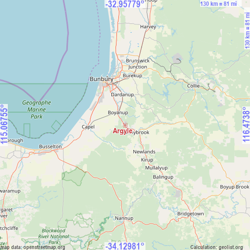
Argyle GPS coordinates[2]
33° 32' 44.844" South, 115° 46' 14.412" East
| Map corner | latitude | longitude |
|---|---|---|
| Upper-left | -32.95779°, | 115.06755° |
| Center: | -33.54579°, | 115.77067° |
| Lower-right: | -34.12981°, | 116.4738° |
| Map W x H: | 130.3×130.3 km | = 81×81mi |
| max Lat: | -10.58257° ⇑47% North |
| Argyle: | -33.54579° |
| min Lat: | ⇓53% South -43.31423° |
| min Long | Argyle | max Long |
| 113.53327° | 115.77067° | 153.61246° |
| W 3.2%⇐ | ⇒96.8% E |
Elevation
Elevation of Argyle is 54 m = 177 ft, and this is 68 m = 223 ft below average elevation for this country.
| Max E: |
1715 m = 5627 ft | 44.6% |
| Avg. | 122 m = 400 ft | |
| Argyle | 54 m = 177 ft | |
Min E: |
-2 m = -7 ft | 55.4% |
See also: Australia elevation on elevation.city.
Geographical zone
Argyle is located in South temperate zone (between Tropic of Capricorn and the Antarctic Circle). Distance of this Southern Tropic circle is 1124 km =698.4 mi to North.| Distance of | km | miles | from Argyle |
|---|---|---|---|
| Equator | 3729.9 | 2317.7 | to North |
| Tropic Capricorn | 1124 | 698.4 | to North |
| Antarctic Circle | 3671.2 | 2281.2 | to South |
| South Pole | 6277.1 | 3900.4 | to South |


Nearby cities:
15 places around Argyle: (largest is in red/bold)
• Boyanup
8 km =5 mi,  330°
330°
• Capel
19.3 km =12 mi,  265°
265°
• Carey Park
24.6 km =15.3 mi, 332°
• College Grove
21.5 km =13.4 mi, 331°
• Dalyellup
21 km =13 mi,  316°
316°
• Dardanup West
18.1 km =11.2 mi,  347°
347°
• Donnybrook
5.7 km =3.5 mi,  119°
119°
• East Bunbury
25.5 km =15.8 mi,  336°
336°
• Eaton
26.2 km =16.3 mi, 346°
• Gelorup
18.1 km =11.2 mi, 318°
• Glen Iris
24.9 km =15.5 mi, 338°
• South Bunbury
25.3 km =15.7 mi, 329°
• Stratham
19.4 km =12.1 mi,  298°
298°
• Usher
22.6 km =14 mi, 324°
• Withers
23.7 km =14.7 mi, 326°
Sources, notices
• [Note1] Compared only with cities in Australia existing in our database
• [Src1] Map data: © OpenStreetMap contributors (CC-BY-SA)
• [Src2] Other city data from geonames.org with taken over terms of usage.
• [Src3] Geographical zone / Annual Mean Temperature by Robert A. Rohde @ Wikipedia
