Chelmer geodata
Chelmer (Queensland) is a section of populated place; located in Australia in Australia/Brisbane (GMT+10) time zone. With population of 2,899 people, there are 2318 cities with bigger population in this country. Compared to other cities in Australia, 81.7% of cities are located further ↓South; 90.3% of cities are located further ←West and 85% of cities have higher elevation than Chelmer. Note1


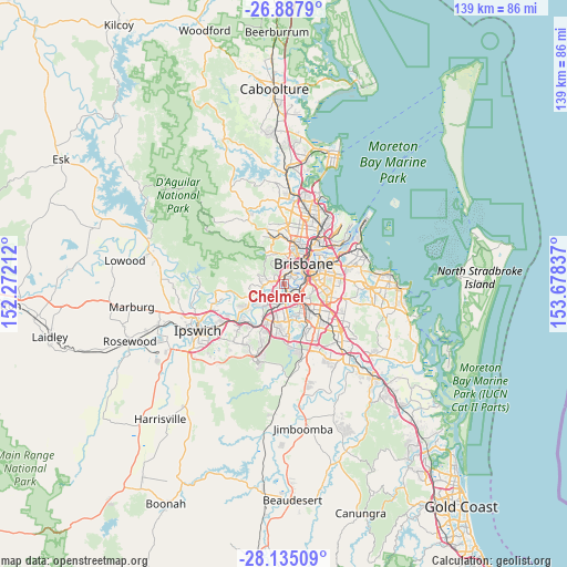
Chelmer GPS coordinates[2]
27° 30' 47.736" South, 152° 58' 30.864" East
| Map corner | latitude | longitude |
|---|---|---|
| Upper-left | -26.8879°, | 152.27212° |
| Center: | -27.51326°, | 152.97524° |
| Lower-right: | -28.13509°, | 153.67837° |
| Map W x H: | 138.7×138.7 km | = 86.2×86.2mi |
| max Lat: | -10.58257° ⇑18.3% North |
| Chelmer: | -27.51326° |
| min Lat: | ⇓81.7% South -43.31423° |
| min Long | Chelmer | max Long |
| 113.53327° | 152.97524° | 153.61246° |
| W 90.3%⇐ | ⇒9.7% E |
Elevation
Elevation of Chelmer is 12 m = 39 ft, and this is 110 m = 361 ft below average elevation for this country.
| Max E: |
1715 m = 5627 ft | 85% |
| Avg. | 122 m = 400 ft | |
| Chelmer | 12 m = 39 ft | |
Min E: |
-2 m = -7 ft | 15% |
See also: Australia elevation on elevation.city.
Geographical zone
Chelmer is located in South temperate zone (between Tropic of Capricorn and the Antarctic Circle). Distance of this Southern Tropic circle is 453.3 km =281.7 mi to North.| Distance of | km | miles | from Chelmer |
|---|---|---|---|
| Equator | 3059.2 | 1900.9 | to North |
| Tropic Capricorn | 453.3 | 281.7 | to North |
| Antarctic Circle | 4342 | 2698 | to South |
| South Pole | 6947.9 | 4317.2 | to South |


Nearby cities:
15 places around Chelmer: (largest is in red/bold)
• Chapel Hill
2.7 km =1.7 mi,  295°
295°
• Corinda
3.5 km =2.2 mi,  168°
168°
• Fig Tree Pocket
2.1 km =1.3 mi,  219°
219°
• Graceville
1.2 km =0.7 mi,  144°
144°
• Indooroopilly
1.1 km =0.7 mi,  359°
359°
• Jindalee
4.3 km =2.7 mi,  236°
236°
• Kenmore
3.6 km =2.2 mi,  279°
279°
• Oxley
4.2 km =2.6 mi, 168°
• Rocklea
4 km =2.5 mi, 135°
• Sinnamon Park
4.3 km =2.7 mi, 216°
• Taringa
2.5 km =1.6 mi,  7°
7°
• Tennyson
2.7 km =1.7 mi,  120°
120°
• Toowong
3.4 km =2.1 mi, 13°
• Yeerongpilly
3.9 km =2.4 mi, 120°
• Yeronga
4.1 km =2.5 mi,  93°
93°
Sources, notices
• [Note1] Compared only with cities in Australia existing in our database
• [Src1] Map data: © OpenStreetMap contributors (CC-BY-SA)
• [Src2] Other city data from geonames.org with taken over terms of usage.
• [Src3] Geographical zone / Annual Mean Temperature by Robert A. Rohde @ Wikipedia
