Graceville geodata
Graceville (Queensland) is a section of populated place; located in Australia in Australia/Brisbane (GMT+10) time zone. With population of 4,515 people, there are 1623 cities with bigger population in this country. Compared to other cities in Australia, 81.6% of cities are located further ↓South; 90.4% of cities are located further ←West and 79% of cities have higher elevation than Graceville. Note1


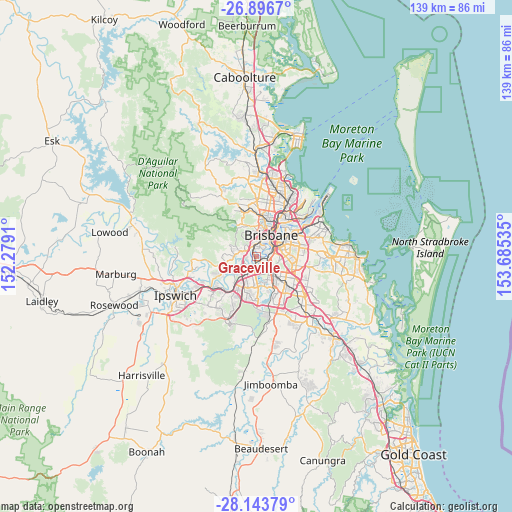
Graceville GPS coordinates[2]
27° 31' 19.236" South, 152° 58' 55.992" East
| Map corner | latitude | longitude |
|---|---|---|
| Upper-left | -26.8967°, | 152.2791° |
| Center: | -27.52201°, | 152.98222° |
| Lower-right: | -28.14379°, | 153.68535° |
| Map W x H: | 138.7×138.7 km | = 86.2×86.2mi |
| max Lat: | -10.58257° ⇑18.4% North |
| Graceville: | -27.52201° |
| min Lat: | ⇓81.6% South -43.31423° |
| min Long | Graceville | max Long |
| 113.53327° | 152.98222° | 153.61246° |
| W 90.4%⇐ | ⇒9.6% E |
Elevation
Elevation of Graceville is 16 m = 52 ft, and this is 106 m = 348 ft below average elevation for this country.
| Max E: |
1715 m = 5627 ft | 79% |
| Avg. | 122 m = 400 ft | |
| Graceville | 16 m = 52 ft | |
Min E: |
-2 m = -7 ft | 21% |
See also: Australia elevation on elevation.city.
Geographical zone
Graceville is located in South temperate zone (between Tropic of Capricorn and the Antarctic Circle). Distance of this Southern Tropic circle is 454.2 km =282.2 mi to North.| Distance of | km | miles | from Graceville |
|---|---|---|---|
| Equator | 3060.2 | 1901.5 | to North |
| Tropic Capricorn | 454.2 | 282.2 | to North |
| Antarctic Circle | 4341 | 2697.4 | to South |
| South Pole | 6946.9 | 4316.6 | to South |


Nearby cities:
15 places around Graceville: (largest is in red/bold)
• Chapel Hill
3.8 km =2.4 mi,  304°
304°
• Chelmer
1.2 km =0.7 mi,  324°
324°
• Corinda
2.4 km =1.5 mi,  180°
180°
• Fig Tree Pocket
2.1 km =1.3 mi,  252°
252°
• Indooroopilly
2.2 km =1.4 mi,  341°
341°
• Moorooka
4.4 km =2.7 mi,  108°
108°
• Oxley
3.1 km =1.9 mi, 177°
• Rocklea
2.9 km =1.8 mi,  131°
131°
• Seventeen Mile Rocks
3.9 km =2.4 mi,  215°
215°
• Sinnamon Park
4.1 km =2.5 mi,  232°
232°
• Taringa
3.5 km =2.2 mi,  354°
354°
• Tennyson
1.7 km =1.1 mi,  104°
104°
• Toowong
4.3 km =2.7 mi,  1°
1°
• Yeerongpilly
2.9 km =1.8 mi, 110°
• Yeronga
3.4 km =2.1 mi,  78°
78°
Sources, notices
• [Note1] Compared only with cities in Australia existing in our database
• [Src1] Map data: © OpenStreetMap contributors (CC-BY-SA)
• [Src2] Other city data from geonames.org with taken over terms of usage.
• [Src3] Geographical zone / Annual Mean Temperature by Robert A. Rohde @ Wikipedia
