Rocklea geodata
Rocklea (Queensland) is a section of populated place; located in Australia in Australia/Brisbane (GMT+10) time zone. With population of 1,596 people, there are 3192 cities with bigger population in this country. Compared to other cities in Australia, 81.1% of cities are located further ↓South; 91.3% of cities are located further ←West and 90.1% of cities have higher elevation than Rocklea. Note1


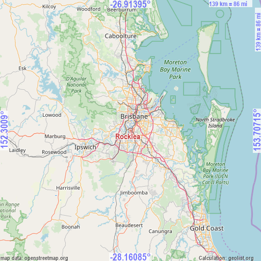
Rocklea GPS coordinates[2]
27° 32' 21.012" South, 153° 0' 14.472" East
| Map corner | latitude | longitude |
|---|---|---|
| Upper-left | -26.91395°, | 152.3009° |
| Center: | -27.53917°, | 153.00402° |
| Lower-right: | -28.16085°, | 153.70715° |
| Map W x H: | 138.6×138.6 km | = 86.1×86.1mi |
| max Lat: | -10.58257° ⇑18.9% North |
| Rocklea: | -27.53917° |
| min Lat: | ⇓81.1% South -43.31423° |
| min Long | Rocklea | max Long |
| 113.53327° | 153.00402° | 153.61246° |
| W 91.3%⇐ | ⇒8.7% E |
Elevation
Elevation of Rocklea is 9 m = 30 ft, and this is 113 m = 371 ft below average elevation for this country.
| Max E: |
1715 m = 5627 ft | 90.1% |
| Avg. | 122 m = 400 ft | |
| Rocklea | 9 m = 30 ft | |
Min E: |
-2 m = -7 ft | 9.9% |
See also: Australia elevation on elevation.city.
Geographical zone
Rocklea is located in South temperate zone (between Tropic of Capricorn and the Antarctic Circle). Distance of this Southern Tropic circle is 456.1 km =283.4 mi to North.| Distance of | km | miles | from Rocklea |
|---|---|---|---|
| Equator | 3062.1 | 1902.7 | to North |
| Tropic Capricorn | 456.1 | 283.4 | to North |
| Antarctic Circle | 4339.1 | 2696.2 | to South |
| South Pole | 6945 | 4315.4 | to South |


Nearby cities:
15 places around Rocklea: (largest is in red/bold)
• Annerley
4.1 km =2.5 mi,  43°
43°
• Archerfield
3.3 km =2.1 mi,  161°
161°
• Chelmer
4 km =2.5 mi,  315°
315°
• Coopers Plains
4.6 km =2.9 mi,  128°
128°
• Corinda
2.2 km =1.4 mi,  256°
256°
• Fairfield
4.2 km =2.6 mi,  29°
29°
• Fig Tree Pocket
4.3 km =2.7 mi,  286°
286°
• Graceville
2.9 km =1.8 mi,  311°
311°
• Moorooka
2.1 km =1.3 mi,  75°
75°
• Oxley
2.4 km =1.5 mi,  239°
239°
• Salisbury
3.1 km =1.9 mi,  115°
115°
• Tarragindi
4.3 km =2.7 mi,  71°
71°
• Tennyson
1.5 km =0.9 mi,  341°
341°
• Yeerongpilly
1.1 km =0.7 mi, 29°
• Yeronga
2.9 km =1.8 mi, 25°
Sources, notices
• [Note1] Compared only with cities in Australia existing in our database
• [Src1] Map data: © OpenStreetMap contributors (CC-BY-SA)
• [Src2] Other city data from geonames.org with taken over terms of usage.
• [Src3] Geographical zone / Annual Mean Temperature by Robert A. Rohde @ Wikipedia
