Oxley geodata
Oxley (Queensland) is a section of populated place; located in Australia in Australia/Brisbane (GMT+10) time zone. With population of 8,344 people, there are 779 cities with bigger population in this country. Compared to other cities in Australia, 80.8% of cities are located further ↓South; 90.5% of cities are located further ←West and 88.3% of cities have higher elevation than Oxley. Note1


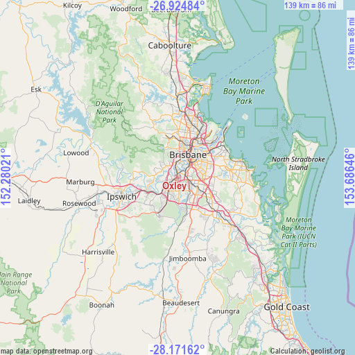
Oxley GPS coordinates[2]
27° 33' 0" South, 152° 58' 59.988" East
| Map corner | latitude | longitude |
|---|---|---|
| Upper-left | -26.92484°, | 152.28021° |
| Center: | -27.55°, | 152.98333° |
| Lower-right: | -28.17162°, | 153.68646° |
| Map W x H: | 138.6×138.6 km | = 86.1×86.1mi |
| max Lat: | -10.58257° ⇑19.2% North |
| Oxley: | -27.55° |
| min Lat: | ⇓80.8% South -43.31423° |
| min Long | Oxley | max Long |
| 113.53327° | 152.98333° | 153.61246° |
| W 90.5%⇐ | ⇒9.5% E |
Elevation
Elevation of Oxley is 10 m = 33 ft, and this is 112 m = 367 ft below average elevation for this country.
| Max E: |
1715 m = 5627 ft | 88.3% |
| Avg. | 122 m = 400 ft | |
| Oxley | 10 m = 33 ft | |
Min E: |
-2 m = -7 ft | 11.7% |
See also: Australia elevation on elevation.city.
Geographical zone
Oxley is located in South temperate zone (between Tropic of Capricorn and the Antarctic Circle). Distance of this Southern Tropic circle is 457.4 km =284.2 mi to North.| Distance of | km | miles | from Oxley |
|---|---|---|---|
| Equator | 3063.3 | 1903.4 | to North |
| Tropic Capricorn | 457.4 | 284.2 | to North |
| Antarctic Circle | 4337.9 | 2695.4 | to South |
| South Pole | 6943.8 | 4314.7 | to South |


Nearby cities:
15 places around Oxley: (largest is in red/bold)
• Archerfield
3.6 km =2.2 mi,  121°
121°
• Chelmer
4.2 km =2.6 mi,  348°
348°
• Corinda
0.7 km =0.4 mi, 350°
• Darra
3.5 km =2.2 mi,  236°
236°
• Durack
4.4 km =2.7 mi,  176°
176°
• Fig Tree Pocket
3.2 km =2 mi,  319°
319°
• Graceville
3.1 km =1.9 mi,  357°
357°
• Jindalee
4.8 km =3 mi,  291°
291°
• Moorooka
4.4 km =2.7 mi,  66°
66°
• Rocklea
2.4 km =1.5 mi,  59°
59°
• Salisbury
4.8 km =3 mi,  91°
91°
• Seventeen Mile Rocks
2.4 km =1.5 mi,  268°
268°
• Sinnamon Park
3.5 km =2.2 mi,  280°
280°
• Tennyson
3.1 km =1.9 mi,  30°
30°
• Yeerongpilly
3.3 km =2.1 mi,  50°
50°
Sources, notices
• [Note1] Compared only with cities in Australia existing in our database
• [Src1] Map data: © OpenStreetMap contributors (CC-BY-SA)
• [Src2] Other city data from geonames.org with taken over terms of usage.
• [Src3] Geographical zone / Annual Mean Temperature by Robert A. Rohde @ Wikipedia
