Ourimbah geodata
Ourimbah (New South Wales) is a section of populated place; located in Australia in Australia/Sydney (GMT+11) time zone. With population of 3,901 people, there are 1823 cities with bigger population in this country. Compared to other cities in Australia, 55.3% of cities are located further ↓South; 76.2% of cities are located further ←West and 82.2% of cities have lower elevation than Ourimbah. Note1


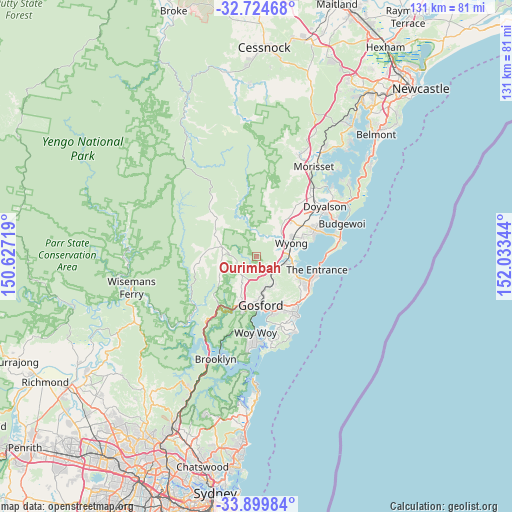
Ourimbah GPS coordinates[2]
33° 18' 51.264" South, 151° 19' 49.116" East
| Map corner | latitude | longitude |
|---|---|---|
| Upper-left | -32.72468°, | 150.62719° |
| Center: | -33.31424°, | 151.33031° |
| Lower-right: | -33.89984°, | 152.03344° |
| Map W x H: | 130.7×130.7 km | = 81.2×81.2mi |
| max Lat: | -10.58257° ⇑44.7% North |
| Ourimbah: | -33.31424° |
| min Lat: | ⇓55.3% South -43.31423° |
| min Long | Ourimbah | max Long |
| 113.53327° | 151.33031° | 153.61246° |
| W 76.2%⇐ | ⇒23.8% E |
Elevation
Elevation of Ourimbah is 207 m = 679 ft, and this is 85 m = 279 ft above average elevation for this country.
| Max E: |
1715 m = 5627 ft | 17.8% |
| Ourimbah | 207 m 679 ft | |
| Avg. | 122 m = 400 ft | |
Min E: |
-2 m = -7 ft | 82.2% |
See also: Australia elevation on elevation.city.
Geographical zone
Ourimbah is located in South temperate zone (between Tropic of Capricorn and the Antarctic Circle). Distance of this Southern Tropic circle is 1098.3 km =682.5 mi to North.| Distance of | km | miles | from Ourimbah |
|---|---|---|---|
| Equator | 3704.2 | 2301.7 | to North |
| Tropic Capricorn | 1098.3 | 682.5 | to North |
| Antarctic Circle | 3697 | 2297.2 | to South |
| South Pole | 6302.9 | 3916.4 | to South |


Nearby cities:
15 places around Ourimbah: (largest is in red/bold)
• Berkeley Vale
10.4 km =6.5 mi,  112°
112°
• Chittaway Bay
9.4 km =5.8 mi,  99°
99°
• Chittaway Point
10.4 km =6.5 mi, 95°
• Fountaindale
7.6 km =4.7 mi,  119°
119°
• Glenning Valley
9.9 km =6.2 mi, 116°
• Lisarow
8.4 km =5.2 mi,  156°
156°
• Mardi
7 km =4.3 mi,  70°
70°
• Narara
9.1 km =5.7 mi,  177°
177°
• Niagara Park
7.1 km =4.4 mi,  166°
166°
• North Gosford
11.3 km =7 mi, 169°
• Somersby
7.3 km =4.5 mi,  216°
216°
• Tuggerah
9.2 km =5.7 mi,  84°
84°
• Watanobbi
10 km =6.2 mi,  58°
58°
• Wyoming
10.4 km =6.5 mi, 163°
• Wyong
9.3 km =5.8 mi, 67°
Sources, notices
• [Note1] Compared only with cities in Australia existing in our database
• [Src1] Map data: © OpenStreetMap contributors (CC-BY-SA)
• [Src2] Other city data from geonames.org with taken over terms of usage.
• [Src3] Geographical zone / Annual Mean Temperature by Robert A. Rohde @ Wikipedia
