Nerang geodata
Nerang (Queensland) is a section of populated place; located in Australia in Australia/Brisbane (GMT+10) time zone. With population of 16,739 people, there are 223 cities with bigger population in this country. Compared to other cities in Australia, 76.2% of cities are located further ↓South; 97.9% of cities are located further ←West and 83.5% of cities have higher elevation than Nerang. Note1


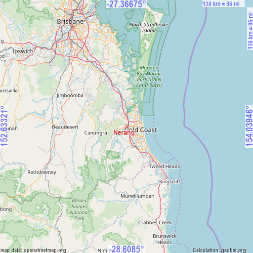
Nerang GPS coordinates[2]
27° 59' 21.876" South, 153° 20' 10.788" East
| Map corner | latitude | longitude |
|---|---|---|
| Upper-left | -27.36675°, | 152.63321° |
| Center: | -27.98941°, | 153.33633° |
| Lower-right: | -28.6085°, | 154.03946° |
| Map W x H: | 138.1×138.1 km | = 85.8×85.8mi |
| max Lat: | -10.58257° ⇑23.8% North |
| Nerang: | -27.98941° |
| min Lat: | ⇓76.2% South -43.31423° |
| min Long | Nerang | max Long |
| 113.53327° | 153.33633° | 153.61246° |
| W 97.9%⇐ | ⇒2.1% E |
Elevation
Elevation of Nerang is 13 m = 43 ft, and this is 109 m = 358 ft below average elevation for this country.
| Max E: |
1715 m = 5627 ft | 83.5% |
| Avg. | 122 m = 400 ft | |
| Nerang | 13 m = 43 ft | |
Min E: |
-2 m = -7 ft | 16.5% |
See also: Australia elevation on elevation.city.
Geographical zone
Nerang is located in South temperate zone (between Tropic of Capricorn and the Antarctic Circle). Distance of this Southern Tropic circle is 506.2 km =314.5 mi to North.| Distance of | km | miles | from Nerang |
|---|---|---|---|
| Equator | 3112.1 | 1933.8 | to North |
| Tropic Capricorn | 506.2 | 314.5 | to North |
| Antarctic Circle | 4289 | 2665.1 | to South |
| South Pole | 6894.9 | 4284.3 | to South |


Nearby cities:
15 places around Nerang: (largest is in red/bold)
• Arundel
6.3 km =3.9 mi,  24°
24°
• Ashmore
3.9 km =2.4 mi,  89°
89°
• Benowa
5.3 km =3.3 mi,  112°
112°
• Bundall
7.1 km =4.4 mi, 109°
• Carrara
4.6 km =2.9 mi,  140°
140°
• Gaven
3.7 km =2.3 mi,  357°
357°
• Gilston
6 km =3.7 mi,  216°
216°
• Highland Park
2.7 km =1.7 mi,  186°
186°
• Merrimac
7.7 km =4.8 mi,  152°
152°
• Molendinar
2.9 km =1.8 mi,  54°
54°
• Mount Nathan
6.9 km =4.3 mi,  293°
293°
• Pacific Pines
5.9 km =3.7 mi,  338°
338°
• Parkwood
4.7 km =2.9 mi,  34°
34°
• Southport
6.5 km =4 mi,  67°
67°
• Worongary
6.9 km =4.3 mi,  168°
168°
Sources, notices
• [Note1] Compared only with cities in Australia existing in our database
• [Src1] Map data: © OpenStreetMap contributors (CC-BY-SA)
• [Src2] Other city data from geonames.org with taken over terms of usage.
• [Src3] Geographical zone / Annual Mean Temperature by Robert A. Rohde @ Wikipedia
