Acacia Ridge geodata
Acacia Ridge (Queensland) is a section of populated place; located in Australia in Australia/Brisbane (GMT+10) time zone. With population of 7,377 people, there are 918 cities with bigger population in this country. Compared to other cities in Australia, 79.9% of cities are located further ↓South; 92.5% of cities are located further ←West and 61.8% of cities have higher elevation than Acacia Ridge. Note1


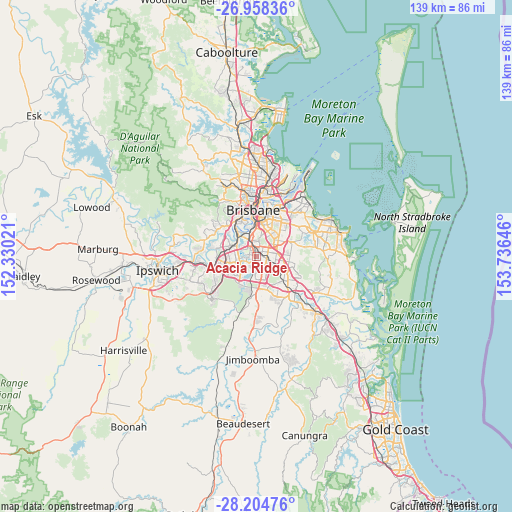
Acacia Ridge GPS coordinates[2]
27° 34' 59.988" South, 153° 1' 59.988" East
| Map corner | latitude | longitude |
|---|---|---|
| Upper-left | -26.95836°, | 152.33021° |
| Center: | -27.58333°, | 153.03333° |
| Lower-right: | -28.20476°, | 153.73646° |
| Map W x H: | 138.6×138.6 km | = 86.1×86.1mi |
| max Lat: | -10.58257° ⇑20.1% North |
| Acacia Ridge: | -27.58333° |
| min Lat: | ⇓79.9% South -43.31423° |
| min Long | Acacia Ridge | max Long |
| 113.53327° | 153.03333° | 153.61246° |
| W 92.5%⇐ | ⇒7.5% E |
Elevation
Elevation of Acacia Ridge is 30 m = 98 ft, and this is 92 m = 302 ft below average elevation for this country.
| Max E: |
1715 m = 5627 ft | 61.8% |
| Avg. | 122 m = 400 ft | |
| Acacia Ridge | 30 m = 98 ft | |
Min E: |
-2 m = -7 ft | 38.2% |
See also: Australia elevation on elevation.city.
Geographical zone
Acacia Ridge is located in South temperate zone (between Tropic of Capricorn and the Antarctic Circle). Distance of this Southern Tropic circle is 461.1 km =286.5 mi to North.| Distance of | km | miles | from Acacia Ridge |
|---|---|---|---|
| Equator | 3067 | 1905.7 | to North |
| Tropic Capricorn | 461.1 | 286.5 | to North |
| Antarctic Circle | 4334.2 | 2693.1 | to South |
| South Pole | 6940.1 | 4312.4 | to South |


Nearby cities:
15 places around Acacia Ridge: (largest is in red/bold)
• Algester
3.3 km =2.1 mi,  181°
181°
• Archerfield
2.6 km =1.6 mi,  314°
314°
• Calamvale
4.7 km =2.9 mi,  162°
162°
• Coopers Plains
2.2 km =1.4 mi,  19°
19°
• Durack
4.7 km =2.9 mi,  261°
261°
• Macgregor
3.9 km =2.4 mi,  57°
57°
• Moorooka
5.5 km =3.4 mi,  351°
351°
• Nathan
3.9 km =2.4 mi,  46°
46°
• Robertson
3.1 km =1.9 mi, 50°
• Runcorn
4.6 km =2.9 mi,  110°
110°
• Salisbury
3.5 km =2.2 mi,  358°
358°
• Stretton
5.4 km =3.4 mi,  143°
143°
• Sunnybank
2.7 km =1.7 mi,  82°
82°
• Sunnybank Hills
3.6 km =2.2 mi,  145°
145°
• Upper Mount Gravatt
5.6 km =3.5 mi, 64°
Sources, notices
• [Note1] Compared only with cities in Australia existing in our database
• [Src1] Map data: © OpenStreetMap contributors (CC-BY-SA)
• [Src2] Other city data from geonames.org with taken over terms of usage.
• [Src3] Geographical zone / Annual Mean Temperature by Robert A. Rohde @ Wikipedia
