Archerfield geodata
Archerfield (Queensland) is a section of populated place; located in Australia in Australia/Brisbane (GMT+10) time zone. With population of 516 people, there are 4827 cities with bigger population in this country. Compared to other cities in Australia, 80.2% of cities are located further ↓South; 91.6% of cities are located further ←West and 85% of cities have higher elevation than Archerfield. Note1


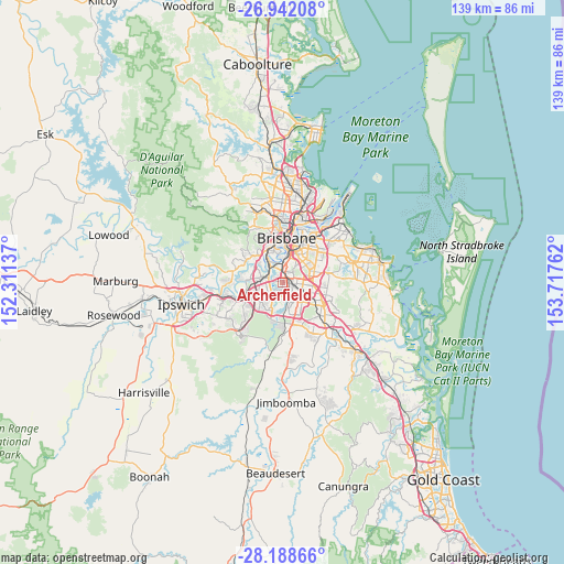
Archerfield GPS coordinates[2]
27° 34' 1.704" South, 153° 0' 52.164" East
| Map corner | latitude | longitude |
|---|---|---|
| Upper-left | -26.94208°, | 152.31137° |
| Center: | -27.56714°, | 153.01449° |
| Lower-right: | -28.18866°, | 153.71762° |
| Map W x H: | 138.6×138.6 km | = 86.1×86.1mi |
| max Lat: | -10.58257° ⇑19.8% North |
| Archerfield: | -27.56714° |
| min Lat: | ⇓80.2% South -43.31423° |
| min Long | Archerfield | max Long |
| 113.53327° | 153.01449° | 153.61246° |
| W 91.6%⇐ | ⇒8.4% E |
Elevation
Elevation of Archerfield is 12 m = 39 ft, and this is 110 m = 361 ft below average elevation for this country.
| Max E: |
1715 m = 5627 ft | 85% |
| Avg. | 122 m = 400 ft | |
| Archerfield | 12 m = 39 ft | |
Min E: |
-2 m = -7 ft | 15% |
See also: Australia elevation on elevation.city.
Geographical zone
Archerfield is located in South temperate zone (between Tropic of Capricorn and the Antarctic Circle). Distance of this Southern Tropic circle is 459.3 km =285.4 mi to North.| Distance of | km | miles | from Archerfield |
|---|---|---|---|
| Equator | 3065.2 | 1904.6 | to North |
| Tropic Capricorn | 459.3 | 285.4 | to North |
| Antarctic Circle | 4336 | 2694.3 | to South |
| South Pole | 6941.9 | 4313.5 | to South |


Nearby cities:
15 places around Archerfield: (largest is in red/bold)
• Acacia Ridge
2.6 km =1.6 mi,  134°
134°
• Coopers Plains
2.6 km =1.6 mi,  83°
83°
• Corinda
4.1 km =2.5 mi,  309°
309°
• Durack
3.8 km =2.4 mi,  228°
228°
• Inala
5.2 km =3.2 mi, 229°
• Macgregor
5.1 km =3.2 mi,  87°
87°
• Moorooka
3.8 km =2.4 mi,  15°
15°
• Nathan
4.8 km =3 mi, 78°
• Oxley
3.6 km =2.2 mi,  301°
301°
• Robertson
4.2 km =2.6 mi, 88°
• Rocklea
3.3 km =2.1 mi,  341°
341°
• Salisbury
2.5 km =1.6 mi,  45°
45°
• Sunnybank
4.8 km =3 mi,  107°
107°
• Tennyson
4.8 km =3 mi, 341°
• Yeerongpilly
4.1 km =2.5 mi,  352°
352°
Sources, notices
• [Note1] Compared only with cities in Australia existing in our database
• [Src1] Map data: © OpenStreetMap contributors (CC-BY-SA)
• [Src2] Other city data from geonames.org with taken over terms of usage.
• [Src3] Geographical zone / Annual Mean Temperature by Robert A. Rohde @ Wikipedia
