Cashmere geodata
Cashmere (Queensland) is a section of populated place; located in Australia in Australia/Brisbane (GMT+10) time zone. With population of 4,832 people, there are 1526 cities with bigger population in this country. Compared to other cities in Australia, 84.6% of cities are located further ↓South; 88.6% of cities are located further ←West and 67% of cities have lower elevation than Cashmere. Note1


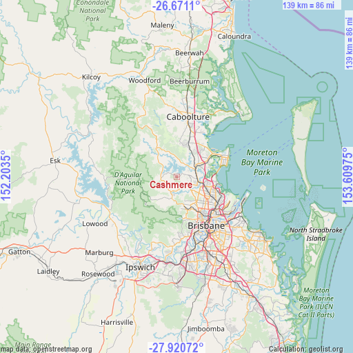
Cashmere GPS coordinates[2]
27° 17' 51.612" South, 152° 54' 23.832" East
| Map corner | latitude | longitude |
|---|---|---|
| Upper-left | -26.6711°, | 152.2035° |
| Center: | -27.29767°, | 152.90662° |
| Lower-right: | -27.92072°, | 153.60975° |
| Map W x H: | 138.9×138.9 km | = 86.3×86.3mi |
| max Lat: | -10.58257° ⇑15.4% North |
| Cashmere: | -27.29767° |
| min Lat: | ⇓84.6% South -43.31423° |
| min Long | Cashmere | max Long |
| 113.53327° | 152.90662° | 153.61246° |
| W 88.6%⇐ | ⇒11.4% E |
Elevation
Elevation of Cashmere is 88 m = 289 ft, and this is 34 m = 112 ft below average elevation for this country.
| Max E: |
1715 m = 5627 ft | 33% |
| Avg. | 122 m = 400 ft | |
| Cashmere | 88 m = 289 ft | |
Min E: |
-2 m = -7 ft | 67% |
See also: Australia elevation on elevation.city.
Geographical zone
Cashmere is located in South temperate zone (between Tropic of Capricorn and the Antarctic Circle). Distance of this Southern Tropic circle is 429.3 km =266.8 mi to North.| Distance of | km | miles | from Cashmere |
|---|---|---|---|
| Equator | 3035.2 | 1886 | to North |
| Tropic Capricorn | 429.3 | 266.8 | to North |
| Antarctic Circle | 4366 | 2712.9 | to South |
| South Pole | 6971.8 | 4332.1 | to South |


Nearby cities:
15 places around Cashmere: (largest is in red/bold)
• Bray Park
6.1 km =3.8 mi,  84°
84°
• Brendale
8.1 km =5 mi,  108°
108°
• Clear Mountain
2.5 km =1.6 mi,  250°
250°
• Closeburn
5.3 km =3.3 mi,  231°
231°
• Draper
6.1 km =3.8 mi,  180°
180°
• Eatons Hill
7 km =4.3 mi,  131°
131°
• Joyner
4.5 km =2.8 mi,  57°
57°
• Lawnton
7.7 km =4.8 mi, 78°
• Mount Samson
5.6 km =3.5 mi,  267°
267°
• Petrie
8.3 km =5.2 mi,  65°
65°
• Samford
8.6 km =5.3 mi,  193°
193°
• Samson Vale
6.6 km =4.1 mi,  301°
301°
• Strathpine
8.2 km =5.1 mi,  95°
95°
• Warner
4.6 km =2.9 mi, 110°
• Whiteside
4.5 km =2.8 mi,  6°
6°
Sources, notices
• [Note1] Compared only with cities in Australia existing in our database
• [Src1] Map data: © OpenStreetMap contributors (CC-BY-SA)
• [Src2] Other city data from geonames.org with taken over terms of usage.
• [Src3] Geographical zone / Annual Mean Temperature by Robert A. Rohde @ Wikipedia
