Mirrabooka geodata
Mirrabooka (Western Australia) is a section of populated place; located in Australia in Australia/Perth (GMT+8) time zone. With population of 8,085 people, there are 822 cities with bigger population in this country. Compared to other cities in Australia, 67.5% of cities are located further ↓South; 94.4% of cities are located further →East and 60% of cities have lower elevation than Mirrabooka. Note1


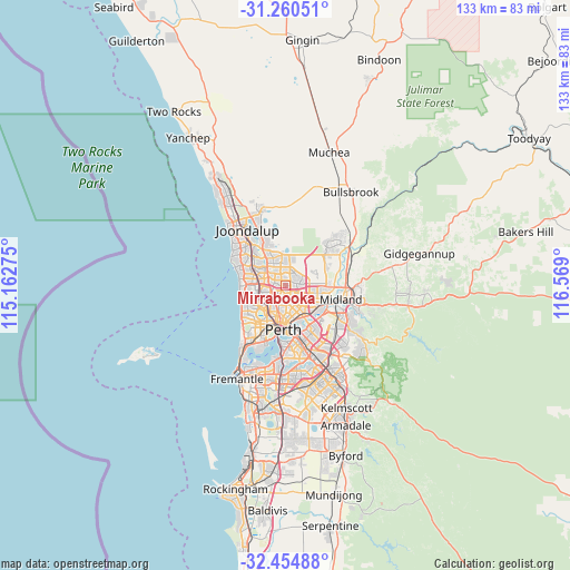
Mirrabooka GPS coordinates[2]
31° 51' 34.668" South, 115° 51' 57.132" East
| Map corner | latitude | longitude |
|---|---|---|
| Upper-left | -31.26051°, | 115.16275° |
| Center: | -31.85963°, | 115.86587° |
| Lower-right: | -32.45488°, | 116.569° |
| Map W x H: | 132.8×132.8 km | = 82.5×82.5mi |
| max Lat: | -10.58257° ⇑32.5% North |
| Mirrabooka: | -31.85963° |
| min Lat: | ⇓67.5% South -43.31423° |
| min Long | Mirrabooka | max Long |
| 113.53327° | 115.86587° | 153.61246° |
| W 5.6%⇐ | ⇒94.4% E |
Elevation
Elevation of Mirrabooka is 64 m = 210 ft, and this is 58 m = 190 ft below average elevation for this country.
| Max E: |
1715 m = 5627 ft | 40% |
| Avg. | 122 m = 400 ft | |
| Mirrabooka | 64 m = 210 ft | |
Min E: |
-2 m = -7 ft | 60% |
See also: Australia elevation on elevation.city.
Geographical zone
Mirrabooka is located in South temperate zone (between Tropic of Capricorn and the Antarctic Circle). Distance of this Southern Tropic circle is 936.5 km =581.9 mi to North.| Distance of | km | miles | from Mirrabooka |
|---|---|---|---|
| Equator | 3542.5 | 2201.2 | to North |
| Tropic Capricorn | 936.5 | 581.9 | to North |
| Antarctic Circle | 3858.7 | 2397.7 | to South |
| South Pole | 6464.6 | 4016.9 | to South |


Nearby cities:
15 places around Mirrabooka: (largest is in red/bold)
• Alexander Heights
3.6 km =2.2 mi,  358°
358°
• Balcatta
3.9 km =2.4 mi,  244°
244°
• Balga
2.5 km =1.6 mi,  281°
281°
• Ballajura
3.5 km =2.2 mi,  52°
52°
• Dianella
3.2 km =2 mi,  169°
169°
• Girrawheen
3.2 km =2 mi,  310°
310°
• Hamersley
5.6 km =3.5 mi, 282°
• Koondoola
2 km =1.2 mi,  1°
1°
• Marangaroo
4.4 km =2.7 mi,  324°
324°
• Morley
5.2 km =3.2 mi,  126°
126°
• Nollamara
3 km =1.9 mi,  220°
220°
• Noranda
3.5 km =2.2 mi,  115°
115°
• Tuart Hill
5.2 km =3.2 mi,  214°
214°
• Westminster
2.7 km =1.7 mi,  250°
250°
• Yokine
4.8 km =3 mi,  194°
194°
Sources, notices
• [Note1] Compared only with cities in Australia existing in our database
• [Src1] Map data: © OpenStreetMap contributors (CC-BY-SA)
• [Src2] Other city data from geonames.org with taken over terms of usage.
• [Src3] Geographical zone / Annual Mean Temperature by Robert A. Rohde @ Wikipedia
