Granville geodata
Granville (Queensland) is a section of populated place; located in Australia in Australia/Brisbane (GMT+10) time zone. With population of 2,667 people, there are 2454 cities with bigger population in this country. Compared to other cities in Australia, 88.9% of cities are located further ↓South; 86.1% of cities are located further ←West and 81.9% of cities have higher elevation than Granville. Note1


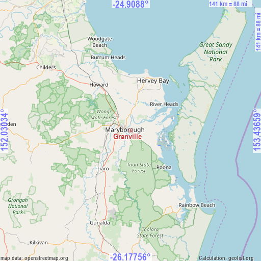
Granville GPS coordinates[2]
25° 32' 41.496" South, 152° 44' 0.456" East
| Map corner | latitude | longitude |
|---|---|---|
| Upper-left | -24.9088°, | 152.03034° |
| Center: | -25.54486°, | 152.73346° |
| Lower-right: | -26.17756°, | 153.43659° |
| Map W x H: | 141.1×141.1 km | = 87.7×87.7mi |
| max Lat: | -10.58257° ⇑11.1% North |
| Granville: | -25.54486° |
| min Lat: | ⇓88.9% South -43.31423° |
| min Long | Granville | max Long |
| 113.53327° | 152.73346° | 153.61246° |
| W 86.1%⇐ | ⇒13.9% E |
Elevation
Elevation of Granville is 14 m = 46 ft, and this is 108 m = 354 ft below average elevation for this country.
| Max E: |
1715 m = 5627 ft | 81.9% |
| Avg. | 122 m = 400 ft | |
| Granville | 14 m = 46 ft | |
Min E: |
-2 m = -7 ft | 18.1% |
See also: Australia elevation on elevation.city.
Geographical zone
Granville is located in South temperate zone (between Tropic of Capricorn and the Antarctic Circle). Distance of this Southern Tropic circle is 234.4 km =145.6 mi to North.| Distance of | km | miles | from Granville |
|---|---|---|---|
| Equator | 2840.3 | 1764.9 | to North |
| Tropic Capricorn | 234.4 | 145.6 | to North |
| Antarctic Circle | 4560.9 | 2834 | to South |
| South Pole | 7166.7 | 4453.2 | to South |


Nearby cities:
15 places around Granville: (largest is in red/bold)
• Aldershot
11.5 km =7.1 mi,  322°
322°
• Booral
27 km =16.8 mi,  40°
40°
• Dundowran
28.1 km =17.5 mi,  8°
8°
• Maryborough
2.9 km =1.8 mi,  279°
279°
• Maryborough West
8 km =5 mi,  303°
303°
• Nikenbah
26.1 km =16.2 mi,  15°
15°
• Oakhurst
10.4 km =6.5 mi,  290°
290°
• Poona
25.9 km =16.1 mi,  137°
137°
• River Heads
23.1 km =14.4 mi,  51°
51°
• Sunshine Acres
21.5 km =13.4 mi, 14°
• Takura
25.5 km =15.8 mi,  351°
351°
• Tiaro
25.2 km =15.7 mi,  216°
216°
• Tinana
6.8 km =4.2 mi,  263°
263°
• Torbanlea
26.2 km =16.3 mi,  327°
327°
• Wondunna
28.2 km =17.5 mi,  26°
26°
Sources, notices
• [Note1] Compared only with cities in Australia existing in our database
• [Src1] Map data: © OpenStreetMap contributors (CC-BY-SA)
• [Src2] Other city data from geonames.org with taken over terms of usage.
• [Src3] Geographical zone / Annual Mean Temperature by Robert A. Rohde @ Wikipedia
