Tinana geodata
Tinana (Queensland) is a section of populated place; located in Australia in Australia/Brisbane (GMT+10) time zone. With population of 5,408 people, there are 1371 cities with bigger population in this country. Compared to other cities in Australia, 88.9% of cities are located further ↓South; 85.5% of cities are located further ←West and 74.7% of cities have higher elevation than Tinana. Note1


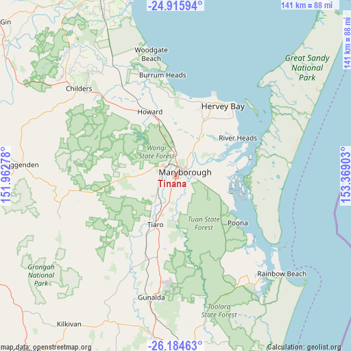
Tinana GPS coordinates[2]
25° 33' 7.056" South, 152° 39' 57.24" East
| Map corner | latitude | longitude |
|---|---|---|
| Upper-left | -24.91594°, | 151.96278° |
| Center: | -25.55196°, | 152.6659° |
| Lower-right: | -26.18463°, | 153.36903° |
| Map W x H: | 141.1×141.1 km | = 87.7×87.7mi |
| max Lat: | -10.58257° ⇑11.1% North |
| Tinana: | -25.55196° |
| min Lat: | ⇓88.9% South -43.31423° |
| min Long | Tinana | max Long |
| 113.53327° | 152.6659° | 153.61246° |
| W 85.5%⇐ | ⇒14.5% E |
Elevation
Elevation of Tinana is 19 m = 62 ft, and this is 103 m = 338 ft below average elevation for this country.
| Max E: |
1715 m = 5627 ft | 74.7% |
| Avg. | 122 m = 400 ft | |
| Tinana | 19 m = 62 ft | |
Min E: |
-2 m = -7 ft | 25.3% |
See also: Australia elevation on elevation.city.
Geographical zone
Tinana is located in South temperate zone (between Tropic of Capricorn and the Antarctic Circle). Distance of this Southern Tropic circle is 235.2 km =146.1 mi to North.| Distance of | km | miles | from Tinana |
|---|---|---|---|
| Equator | 2841.1 | 1765.4 | to North |
| Tropic Capricorn | 235.2 | 146.1 | to North |
| Antarctic Circle | 4560.1 | 2833.5 | to South |
| South Pole | 7166 | 4452.7 | to South |


Nearby cities:
15 places around Tinana: (largest is in red/bold)
• Aldershot
9.9 km =6.2 mi,  358°
358°
• Bauple
29.3 km =18.2 mi,  188°
188°
• Craignish
30.5 km =19 mi,  11°
11°
• Granville
6.8 km =4.2 mi,  83°
83°
• Howard
28 km =17.4 mi,  337°
337°
• Maryborough
4.1 km =2.5 mi,  72°
72°
• Maryborough West
5.2 km =3.2 mi,  0°
0°
• Nikenbah
29.4 km =18.3 mi,  28°
28°
• Oakhurst
5.3 km =3.3 mi,  325°
325°
• Poona
30.4 km =18.9 mi,  126°
126°
• River Heads
29.1 km =18.1 mi,  58°
58°
• Sunshine Acres
24.8 km =15.4 mi, 29°
• Takura
26.2 km =16.3 mi, 6°
• Tiaro
21.1 km =13.1 mi,  203°
203°
• Torbanlea
24.1 km =15 mi, 342°
Sources, notices
• [Note1] Compared only with cities in Australia existing in our database
• [Src1] Map data: © OpenStreetMap contributors (CC-BY-SA)
• [Src2] Other city data from geonames.org with taken over terms of usage.
• [Src3] Geographical zone / Annual Mean Temperature by Robert A. Rohde @ Wikipedia
