Poona geodata
Poona (Queensland) is a section of populated place; located in Australia in Australia/Brisbane (GMT+10) time zone. With population of 525 people, there are 4798 cities with bigger population in this country. Compared to other cities in Australia, 88.8% of cities are located further ↓South; 88.7% of cities are located further ←West and 95.5% of cities have higher elevation than Poona. Note1


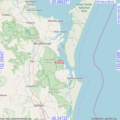
Poona GPS coordinates[2]
25° 42' 55.548" South, 152° 54' 34.38" East
| Map corner | latitude | longitude |
|---|---|---|
| Upper-left | -25.08027°, | 152.20643° |
| Center: | -25.71543°, | 152.90955° |
| Lower-right: | -26.34722°, | 153.61268° |
| Map W x H: | 140.9×140.9 km | = 87.6×87.6mi |
| max Lat: | -10.58257° ⇑11.2% North |
| Poona: | -25.71543° |
| min Lat: | ⇓88.8% South -43.31423° |
| min Long | Poona | max Long |
| 113.53327° | 152.90955° | 153.61246° |
| W 88.7%⇐ | ⇒11.3% E |
Elevation
Elevation of Poona is 6 m = 20 ft, and this is 116 m = 381 ft below average elevation for this country.
| Max E: |
1715 m = 5627 ft | 95.5% |
| Avg. | 122 m = 400 ft | |
| Poona | 6 m = 20 ft | |
Min E: |
-2 m = -7 ft | 4.5% |
See also: Australia elevation on elevation.city.
Geographical zone
Poona is located in South temperate zone (between Tropic of Capricorn and the Antarctic Circle). Distance of this Southern Tropic circle is 253.4 km =157.5 mi to North.| Distance of | km | miles | from Poona |
|---|---|---|---|
| Equator | 2859.3 | 1776.7 | to North |
| Tropic Capricorn | 253.4 | 157.5 | to North |
| Antarctic Circle | 4541.9 | 2822.2 | to South |
| South Pole | 7147.8 | 4441.4 | to South |


Nearby cities:
15 places around Poona: (largest is in red/bold)
• Aldershot
37.4 km =23.2 mi,  318°
318°
• Bauple
30.8 km =19.1 mi,  249°
249°
• Booral
39.5 km =24.5 mi,  359°
359°
• Cooloola Cove
31.3 km =19.4 mi,  164°
164°
• Granville
25.9 km =16.1 mi, 317°
• Maryborough
28.3 km =17.6 mi,  313°
313°
• Maryborough West
33.8 km =21 mi, 313°
• Oakhurst
35.5 km =22.1 mi, 309°
• Rainbow Beach
27.8 km =17.3 mi,  139°
139°
• River Heads
33.3 km =20.7 mi,  0°
0°
• Sunshine Acres
41.6 km =25.8 mi,  342°
342°
• Tiaro
32.8 km =20.4 mi,  267°
267°
• Tin Can Bay
24.5 km =15.2 mi, 157°
• Tinana
30.4 km =18.9 mi, 306°
• Wondunna
44.5 km =27.7 mi,  353°
353°
Sources, notices
• [Note1] Compared only with cities in Australia existing in our database
• [Src1] Map data: © OpenStreetMap contributors (CC-BY-SA)
• [Src2] Other city data from geonames.org with taken over terms of usage.
• [Src3] Geographical zone / Annual Mean Temperature by Robert A. Rohde @ Wikipedia
