Tiaro geodata
Tiaro (Queensland) is a populated place; located in Australia in Australia/Brisbane (GMT+10) time zone. With population of 764 people, there are 4216 cities with bigger population in this country. Compared to other cities in Australia, 88.8% of cities are located further ↓South; 84.9% of cities are located further ←West and 55.2% of cities have higher elevation than Tiaro. Note1


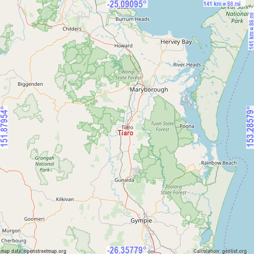
Tiaro GPS coordinates[2]
25° 43' 33.816" South, 152° 34' 57.576" East
| Map corner | latitude | longitude |
|---|---|---|
| Upper-left | -25.09095°, | 151.87954° |
| Center: | -25.72606°, | 152.58266° |
| Lower-right: | -26.35779°, | 153.28579° |
| Map W x H: | 140.9×140.9 km | = 87.6×87.6mi |
| max Lat: | -10.58257° ⇑11.2% North |
| Tiaro: | -25.72606° |
| min Lat: | ⇓88.8% South -43.31423° |
| min Long | Tiaro | max Long |
| 113.53327° | 152.58266° | 153.61246° |
| W 84.9%⇐ | ⇒15.1% E |
Elevation
Elevation of Tiaro is 38 m = 125 ft, and this is 84 m = 276 ft below average elevation for this country.
| Max E: |
1715 m = 5627 ft | 55.2% |
| Avg. | 122 m = 400 ft | |
| Tiaro | 38 m = 125 ft | |
Min E: |
-2 m = -7 ft | 44.8% |
See also: Australia elevation on elevation.city.
Geographical zone
Tiaro is located in South temperate zone (between Tropic of Capricorn and the Antarctic Circle). Distance of this Southern Tropic circle is 254.6 km =158.2 mi to North.| Distance of | km | miles | from Tiaro |
|---|---|---|---|
| Equator | 2860.5 | 1777.4 | to North |
| Tropic Capricorn | 254.6 | 158.2 | to North |
| Antarctic Circle | 4540.7 | 2821.5 | to South |
| South Pole | 7146.6 | 4440.7 | to South |


Nearby cities:
15 places around Tiaro: (largest is in red/bold)
• Aldershot
30.3 km =18.8 mi,  15°
15°
• Bauple
10.3 km =6.4 mi,  157°
157°
• Chatsworth
46.6 km =29 mi,  176°
176°
• Curra
37.9 km =23.5 mi, 179°
• Granville
25.2 km =15.7 mi,  36°
36°
• Howard
45.3 km =28.1 mi,  357°
357°
• Maryborough
24 km =14.9 mi,  30°
30°
• Maryborough West
25.9 km =16.1 mi, 18°
• Oakhurst
24.3 km =15.1 mi,  12°
12°
• Poona
32.8 km =20.4 mi,  87°
87°
• Sunshine Acres
45.8 km =28.5 mi, 26°
• Takura
46.8 km =29.1 mi, 14°
• Tamaree
46.1 km =28.6 mi,  169°
169°
• Tinana
21.1 km =13.1 mi, 23°
• Torbanlea
42.3 km =26.3 mi,  1°
1°
Sources, notices
• [Note1] Compared only with cities in Australia existing in our database
• [Src1] Map data: © OpenStreetMap contributors (CC-BY-SA)
• [Src2] Other city data from geonames.org with taken over terms of usage.
• [Src3] Geographical zone / Annual Mean Temperature by Robert A. Rohde @ Wikipedia
