Wright geodata
Wright (ACT) is a section of populated place; located in Australia in Australia/Sydney (GMT+11) time zone. With population of 2,763 people, there are 2404 cities with bigger population in this country. Compared to other cities in Australia, 75.6% of cities are located further ↑North; 52.9% of cities are located further ←West and 95.8% of cities have lower elevation than Wright. Note1


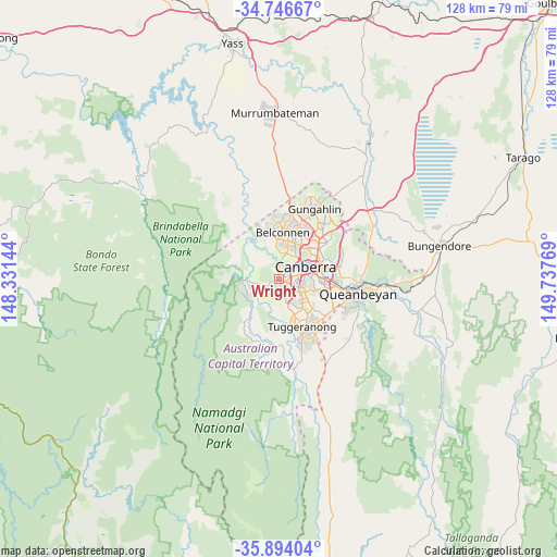
Wright GPS coordinates[2]
35° 19' 20.604" South, 149° 2' 4.416" East
| Map corner | latitude | longitude |
|---|---|---|
| Upper-left | -34.74667°, | 148.33144° |
| Center: | -35.32239°, | 149.03456° |
| Lower-right: | -35.89404°, | 149.73769° |
| Map W x H: | 127.6×127.6 km | = 79.3×79.3mi |
| max Lat: | -10.58257° ⇑75.6% North |
| Wright: | -35.32239° |
| min Lat: | ⇓24.4% South -43.31423° |
| min Long | Wright | max Long |
| 113.53327° | 149.03456° | 153.61246° |
| W 52.9%⇐ | ⇒47.1% E |
Elevation
Elevation of Wright is 599 m = 1965 ft, and this is 477 m = 1565 ft above average elevation for this country.
| Max E: |
1715 m = 5627 ft | 4.2% |
| Wright | 599 m 1965 ft | |
| Avg. | 122 m = 400 ft | |
Min E: |
-2 m = -7 ft | 95.8% |
See also: Australia elevation on elevation.city.
Geographical zone
Wright is located in South temperate zone (between Tropic of Capricorn and the Antarctic Circle). Distance of this Southern Tropic circle is 1321.6 km =821.2 mi to North.| Distance of | km | miles | from Wright |
|---|---|---|---|
| Equator | 3927.5 | 2440.4 | to North |
| Tropic Capricorn | 1321.6 | 821.2 | to North |
| Antarctic Circle | 3473.7 | 2158.5 | to South |
| South Pole | 6079.6 | 3777.7 | to South |


Nearby cities:
15 places around Wright: (largest is in red/bold)
• Chapman
3.8 km =2.4 mi,  176°
176°
• Chifley
5.2 km =3.2 mi,  131°
131°
• Coombs
0.8 km =0.5 mi,  33°
33°
• Curtin
3.9 km =2.4 mi,  93°
93°
• Deakin
6.2 km =3.9 mi, 86°
• Duffy
1.4 km =0.9 mi,  190°
190°
• Fisher
4.8 km =3 mi,  154°
154°
• Holder
1.7 km =1.1 mi,  141°
141°
• Hughes
5.6 km =3.5 mi,  101°
101°
• Lyons
4.1 km =2.5 mi,  119°
119°
• Phillip
6 km =3.7 mi, 121°
• Rivett
2.8 km =1.7 mi,  173°
173°
• Stirling
3.3 km =2.1 mi,  156°
156°
• Waramanga
4.2 km =2.6 mi, 143°
• Weston
2.7 km =1.7 mi, 123°
Sources, notices
• [Note1] Compared only with cities in Australia existing in our database
• [Src1] Map data: © OpenStreetMap contributors (CC-BY-SA)
• [Src2] Other city data from geonames.org with taken over terms of usage.
• [Src3] Geographical zone / Annual Mean Temperature by Robert A. Rohde @ Wikipedia
