Yungaburra geodata
Yungaburra (Queensland) is a populated place; located in Australia in Australia/Brisbane (GMT+10) time zone. With population of 1,357 people, there are 3411 cities with bigger population in this country. Compared to other cities in Australia, 96.7% of cities are located further ↓South; 59.2% of cities are located further →East and 98.4% of cities have lower elevation than Yungaburra. Note1


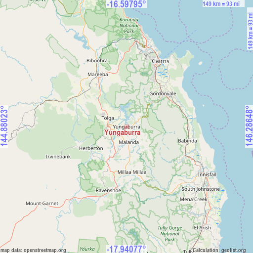
Yungaburra GPS coordinates[2]
17° 16' 14.088" South, 145° 35' 0.06" East
| Map corner | latitude | longitude |
|---|---|---|
| Upper-left | -16.59795°, | 144.88023° |
| Center: | -17.27058°, | 145.58335° |
| Lower-right: | -17.94077°, | 146.28648° |
| Map W x H: | 149.3×149.3 km | = 92.8×92.8mi |
| max Lat: | -10.58257° ⇑3.3% North |
| Yungaburra: | -17.27058° |
| min Lat: | ⇓96.7% South -43.31423° |
| min Long | Yungaburra | max Long |
| 113.53327° | 145.58335° | 153.61246° |
| W 40.8%⇐ | ⇒59.2% E |
Elevation
Elevation of Yungaburra is 703 m = 2306 ft, and this is 581 m = 1906 ft above average elevation for this country.
| Max E: |
1715 m = 5627 ft | 1.6% |
| Yungaburra | 703 m 2306 ft | |
| Avg. | 122 m = 400 ft | |
Min E: |
-2 m = -7 ft | 98.4% |
See also: Australia elevation on elevation.city.
Geographical zone
Yungaburra is located in South Torrid zone (between Equator and Tropic of Capricorn). Distance of this Southern Tropic circle is 685.6 km =426 mi to South.| Distance of | km | miles | from Yungaburra |
|---|---|---|---|
| Equator | 1920.3 | 1193.2 | to North |
| Tropic Capricorn | 685.6 | 426 | to South |
| Antarctic Circle | 5480.9 | 3405.7 | to South |
| South Pole | 8086.8 | 5024.9 | to South |


Nearby cities:
15 places around Yungaburra: (largest is in red/bold)
• Aloomba
32 km =19.9 mi,  56°
56°
• Atherton
11.5 km =7.1 mi,  271°
271°
• Bentley Park
33.9 km =21.1 mi,  29°
29°
• Edmonton
32.8 km =20.4 mi, 31°
• Goldsborough
20.8 km =12.9 mi,  51°
51°
• Gordonvale
28.3 km =17.6 mi, 47°
• Herberton
24 km =14.9 mi,  241°
241°
• Malanda
9.2 km =5.7 mi,  172°
172°
• Mareeba
35.5 km =22.1 mi,  331°
331°
• Millaa Millaa
27.2 km =16.9 mi, 173°
• Mount Sheridan
35.4 km =22 mi, 26°
• Peeramon
5.3 km =3.3 mi,  146°
146°
• Tolga
14.7 km =9.1 mi,  309°
309°
• Walkamin
23.1 km =14.4 mi, 310°
• Wondecla
25.3 km =15.7 mi,  230°
230°
Sources, notices
• [Note1] Compared only with cities in Australia existing in our database
• [Src1] Map data: © OpenStreetMap contributors (CC-BY-SA)
• [Src2] Other city data from geonames.org with taken over terms of usage.
• [Src3] Geographical zone / Annual Mean Temperature by Robert A. Rohde @ Wikipedia
