Noranda geodata
Noranda (Western Australia) is a section of populated place; located in Australia in Australia/Perth (GMT+8) time zone. With population of 7,853 people, there are 854 cities with bigger population in this country. Compared to other cities in Australia, 67.3% of cities are located further ↓South; 93.9% of cities are located further →East and 56.9% of cities have higher elevation than Noranda. Note1


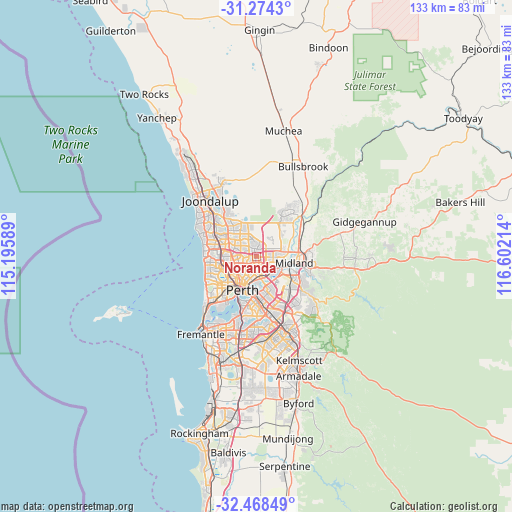
Noranda GPS coordinates[2]
31° 52' 23.988" South, 115° 53' 56.436" East
| Map corner | latitude | longitude |
|---|---|---|
| Upper-left | -31.2743°, | 115.19589° |
| Center: | -31.87333°, | 115.89901° |
| Lower-right: | -32.46849°, | 116.60214° |
| Map W x H: | 132.8×132.8 km | = 82.5×82.5mi |
| max Lat: | -10.58257° ⇑32.7% North |
| Noranda: | -31.87333° |
| min Lat: | ⇓67.3% South -43.31423° |
| min Long | Noranda | max Long |
| 113.53327° | 115.89901° | 153.61246° |
| W 6.1%⇐ | ⇒93.9% E |
Elevation
Elevation of Noranda is 36 m = 118 ft, and this is 86 m = 282 ft below average elevation for this country.
| Max E: |
1715 m = 5627 ft | 56.9% |
| Avg. | 122 m = 400 ft | |
| Noranda | 36 m = 118 ft | |
Min E: |
-2 m = -7 ft | 43.1% |
See also: Australia elevation on elevation.city.
Geographical zone
Noranda is located in South temperate zone (between Tropic of Capricorn and the Antarctic Circle). Distance of this Southern Tropic circle is 938.1 km =582.9 mi to North.| Distance of | km | miles | from Noranda |
|---|---|---|---|
| Equator | 3544 | 2202.1 | to North |
| Tropic Capricorn | 938.1 | 582.9 | to North |
| Antarctic Circle | 3857.2 | 2396.8 | to South |
| South Pole | 6463.1 | 4016 | to South |


Nearby cities:
15 places around Noranda: (largest is in red/bold)
• Ballajura
3.7 km =2.3 mi,  354°
354°
• Bayswater
5.2 km =3.2 mi,  159°
159°
• Bedford
4.3 km =2.7 mi,  192°
192°
• Beechboro
3.7 km =2.3 mi,  75°
75°
• Bennett Springs
4.6 km =2.9 mi,  70°
70°
• Dianella
3.1 km =1.9 mi,  237°
237°
• Eden Hill
4.8 km =3 mi,  111°
111°
• Embleton
3.5 km =2.2 mi, 164°
• Inglewood
5.1 km =3.2 mi,  200°
200°
• Kiara
3.9 km =2.4 mi,  103°
103°
• Koondoola
4.7 km =2.9 mi,  319°
319°
• Lockridge
4.9 km =3 mi, 100°
• Mirrabooka
3.5 km =2.2 mi,  295°
295°
• Morley
1.9 km =1.2 mi,  147°
147°
• Nollamara
5.1 km =3.2 mi,  261°
261°
Sources, notices
• [Note1] Compared only with cities in Australia existing in our database
• [Src1] Map data: © OpenStreetMap contributors (CC-BY-SA)
• [Src2] Other city data from geonames.org with taken over terms of usage.
• [Src3] Geographical zone / Annual Mean Temperature by Robert A. Rohde @ Wikipedia
