Mallacoota geodata
Mallacoota (Victoria) is a populated place; located in Australia in Australia/Melbourne (GMT+11) time zone. With population of 1,062 people, there are 3739 cities with bigger population in this country. Compared to other cities in Australia, 83% of cities are located further ↑North; 56.6% of cities are located further ←West and 70.9% of cities have higher elevation than Mallacoota. Note1


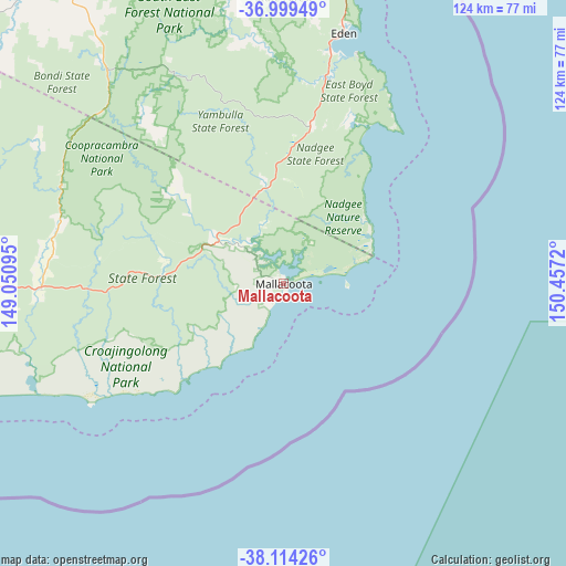
Mallacoota GPS coordinates[2]
37° 33' 32.256" South, 149° 45' 14.652" East
| Map corner | latitude | longitude |
|---|---|---|
| Upper-left | -36.99949°, | 149.05095° |
| Center: | -37.55896°, | 149.75407° |
| Lower-right: | -38.11426°, | 150.4572° |
| Map W x H: | 124×123.9 km | = 77.1×77mi |
| max Lat: | -10.58257° ⇑83% North |
| Mallacoota: | -37.55896° |
| min Lat: | ⇓17% South -43.31423° |
| min Long | Mallacoota | max Long |
| 113.53327° | 149.75407° | 153.61246° |
| W 56.6%⇐ | ⇒43.4% E |
Elevation
Elevation of Mallacoota is 22 m = 72 ft, and this is 100 m = 328 ft below average elevation for this country.
| Max E: |
1715 m = 5627 ft | 70.9% |
| Avg. | 122 m = 400 ft | |
| Mallacoota | 22 m = 72 ft | |
Min E: |
-2 m = -7 ft | 29.1% |
See also: Australia elevation on elevation.city.
Geographical zone
Mallacoota is located in South temperate zone (between Tropic of Capricorn and the Antarctic Circle). Distance of this Southern Tropic circle is 1570.2 km =975.7 mi to North.| Distance of | km | miles | from Mallacoota |
|---|---|---|---|
| Equator | 4176.2 | 2595 | to North |
| Tropic Capricorn | 1570.2 | 975.7 | to North |
| Antarctic Circle | 3225 | 2003.9 | to South |
| South Pole | 5830.9 | 3623.2 | to South |


Nearby cities:
15 places around Mallacoota: (largest is in red/bold)
• Bega
98.7 km =61.3 mi,  4°
4°
• Bemboka
104.7 km =65.1 mi,  351°
351°
• Bermagui
129.7 km =80.6 mi,  12°
12°
• Bombala
85.3 km =53 mi,  327°
327°
• Candelo
88.1 km =54.7 mi,  356°
356°
• Eden
56.2 km =34.9 mi, 13°
• Kalaru
93.3 km =58 mi, 9°
• Marlo
110.7 km =68.8 mi,  256°
256°
• Merimbula
75.8 km =47.1 mi, 10°
• Orbost
115.2 km =71.6 mi, 262°
• Pambula
70.7 km =43.9 mi, 8°
• Pambula Beach
69.9 km =43.4 mi, 10°
• Tathra
94.2 km =58.5 mi, 12°
• Tura Beach
78.9 km =49 mi, 11°
• Wolumla
81.1 km =50.4 mi, 3°
Sources, notices
• [Note1] Compared only with cities in Australia existing in our database
• [Src1] Map data: © OpenStreetMap contributors (CC-BY-SA)
• [Src2] Other city data from geonames.org with taken over terms of usage.
• [Src3] Geographical zone / Annual Mean Temperature by Robert A. Rohde @ Wikipedia
